

The Tactical Assault Kit is DoD nomenclature for the Team Awareness Kit (TAK) application: a mission planning, geospatial, Full Motion Video (FMV), and system administrator tool that reduces the operational footprint from a tactical laptop, to a commercial mobile device. The geospatial engine and communications component support Department of Defense (DoD) and commercial sector standards. Extensibility of the core platform is supported by the Software Development Kit (https://tak.gov), which enables any partner to develop mission-specific capability or contribute to the advancement of the baseline. Data can be pre-loaded into ATAK or downloaded from the network when available.
Civil use capabilities of ATAK-CIV include:
• Online and offline mapping (most standard formats), with a blazing fast rendering engine
• Support for very high-resolution imagery (sub 1 cm resolution)
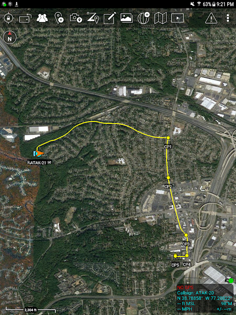
• Collaborative mapping, including points, drawings, locations of interest
• Extensive and customizable set of Icons
• Overlay Manager which allows the Import and display of KML, KMZ, GPX overlays, maps and imagery including both online and offline sources with adjustable transparency. These overlays can be treated as Gridded Refrence Gaphics.
• Location marking, sharing, history
• Chat, file sharing, photo sharing, video sharing, streaming
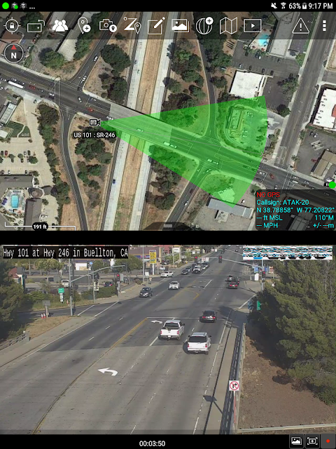
• Navigation-walking/hiking, driving, also useful flying and air-ground coordination
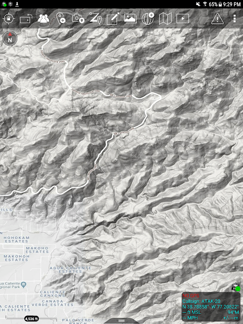
• Elevation Tools, heat maps, computed contour maps, viewsheds, routes w/DTED, SRTM, including dynamic profiling
• Hashtags and Sticky tags
• Center on Self, Center on other objects (e.g. another person in the network)
• Range, bearing, and other measurement tools
• Network-aware geofences with triggers
• "Bloodhound" destination tracking, including on moving objects
• Team Emergency Beacons
• Customizable Toolbar
• Radio controls and Integration
• Photo to map capability (aka Rubber Sheeting)
• Casualty evacuation tool
• Icon support for a wide variety of First Responder missions with further extensible Icons
• 3D perspective and ability to display 3D geospatial models
• Useful for First Responders, Hunting, fishing, ornithology, wildlife site survey
• ATAK-CIV is open source: https://github.com/deptofdefense/AndroidTacticalAssaultKit-CIV
System Requirements
Operating System: ATAK requires Android 5.0 (API 21) or later.
Hardware: ATAK does not require specific hardware and should run on any Android device that supports the other System Requirements.
Graphics: ATAK requires a graphics processor that supports GLES 3.0.
Storage, Memory and Processor: no specific requirements for storage, memory or processor- performance of the application will depend on the configuration.
Recommended for optimal experience: Samsung S9 equivalent hardware or newer is used and for a tablet style device Samsung S2 equivalent or newer.
TAK CORE
TAK CORE includes functionality that is common to all TAK applications and focuses on capabilities that can live in a cross-platform layer (simplifying the development and management of the library).
TAK CORE Features:
Networking – All ATAK applications use a variety of network mediums to send situational awareness data, chat messages, and other file types associated with mission planning activities. The networking component of TAK CORE handles creating the appropriate message at the application level (Cursor-on-Target), manages receiving and dispatching messages, and brokers communication with the TAK Server product.
Geospatial Data Processing – The TAK applications ingest geospatial imagery and overlay products for use on the moving map display.
Geospatial Data Visualization – A set of rendering utility and helper functions exist in TAK CORE to standardize the way geospatial imagery and overlays are rendered to the screen.
Geospatial Data Management – A data management capability is included in the TAK CORE to ensure that the data managed by TAK is relevant and accurate for the end user.
Introduction
ATAK-CIV (Civil Use) is a powerful situational awareness and collaboration tool designed specifically for civilian applications. It provides users with real-time information, geospatial data, and communication capabilities to enhance decision-making and coordination in various scenarios.
Key Features
* Real-time Situational Awareness: ATAK-CIV provides users with a comprehensive view of their surroundings, including terrain data, weather conditions, traffic information, and real-time events.
* Geospatial Data Management: Users can overlay and visualize geospatial data, such as maps, aerial imagery, and CAD drawings, to gain a deeper understanding of the operational environment.
* Communication and Collaboration: ATAK-CIV offers secure text, voice, and video communication, enabling users to collaborate effectively and share information in real-time.
* Data Sharing and Interoperability: ATAK-CIV supports the sharing of data and collaboration with other ATAK users, as well as with external systems through standardized protocols.
* Customizable Interface: The user interface is highly customizable, allowing users to tailor the application to meet their specific needs and preferences.
Applications
ATAK-CIV has a wide range of applications in civilian settings, including:
* Emergency Response: First responders can use ATAK-CIV to access real-time situational awareness, communicate with team members, and coordinate operations during emergencies.
* Public Safety: Law enforcement officers can leverage ATAK-CIV for situational awareness, evidence gathering, and communication with dispatch centers.
* Disaster Management: Disaster relief organizations can use ATAK-CIV to monitor disaster areas, coordinate relief efforts, and communicate with affected communities.
* Infrastructure Management: Utility companies can use ATAK-CIV to visualize infrastructure assets, track maintenance activities, and respond to outages.
* Environmental Monitoring: Environmental organizations can use ATAK-CIV to monitor environmental conditions, collect data, and collaborate with researchers.
Benefits
* Improved Situational Awareness: ATAK-CIV provides users with a comprehensive and real-time view of their surroundings, enhancing their understanding of the operational environment.
* Enhanced Communication and Collaboration: Secure communication capabilities enable users to collaborate effectively and share information in real-time, improving coordination and decision-making.
* Increased Efficiency: ATAK-CIV streamlines workflows and automates tasks, reducing the time and effort required to gather and analyze information.
* Improved Safety: Real-time situational awareness and communication capabilities enhance safety for personnel operating in hazardous or unpredictable environments.
* Cost Savings: ATAK-CIV is a cost-effective solution that eliminates the need for multiple standalone applications, reducing hardware and software expenses.
Conclusion
ATAK-CIV (Civil Use) is an indispensable tool for civilian organizations seeking to enhance situational awareness, improve communication and collaboration, and streamline operations. Its versatility and customizable nature make it suitable for a wide range of applications, empowering users to make informed decisions and respond effectively to complex challenges.
The Tactical Assault Kit is DoD nomenclature for the Team Awareness Kit (TAK) application: a mission planning, geospatial, Full Motion Video (FMV), and system administrator tool that reduces the operational footprint from a tactical laptop, to a commercial mobile device. The geospatial engine and communications component support Department of Defense (DoD) and commercial sector standards. Extensibility of the core platform is supported by the Software Development Kit (https://tak.gov), which enables any partner to develop mission-specific capability or contribute to the advancement of the baseline. Data can be pre-loaded into ATAK or downloaded from the network when available.
Civil use capabilities of ATAK-CIV include:
• Online and offline mapping (most standard formats), with a blazing fast rendering engine
• Support for very high-resolution imagery (sub 1 cm resolution)
• Collaborative mapping, including points, drawings, locations of interest
• Extensive and customizable set of Icons
• Overlay Manager which allows the Import and display of KML, KMZ, GPX overlays, maps and imagery including both online and offline sources with adjustable transparency. These overlays can be treated as Gridded Refrence Gaphics.
• Location marking, sharing, history
• Chat, file sharing, photo sharing, video sharing, streaming
• Navigation-walking/hiking, driving, also useful flying and air-ground coordination
• Elevation Tools, heat maps, computed contour maps, viewsheds, routes w/DTED, SRTM, including dynamic profiling
• Hashtags and Sticky tags
• Center on Self, Center on other objects (e.g. another person in the network)
• Range, bearing, and other measurement tools
• Network-aware geofences with triggers
• "Bloodhound" destination tracking, including on moving objects
• Team Emergency Beacons
• Customizable Toolbar
• Radio controls and Integration
• Photo to map capability (aka Rubber Sheeting)
• Casualty evacuation tool
• Icon support for a wide variety of First Responder missions with further extensible Icons
• 3D perspective and ability to display 3D geospatial models
• Useful for First Responders, Hunting, fishing, ornithology, wildlife site survey
• ATAK-CIV is open source: https://github.com/deptofdefense/AndroidTacticalAssaultKit-CIV
System Requirements
Operating System: ATAK requires Android 5.0 (API 21) or later.
Hardware: ATAK does not require specific hardware and should run on any Android device that supports the other System Requirements.
Graphics: ATAK requires a graphics processor that supports GLES 3.0.
Storage, Memory and Processor: no specific requirements for storage, memory or processor- performance of the application will depend on the configuration.
Recommended for optimal experience: Samsung S9 equivalent hardware or newer is used and for a tablet style device Samsung S2 equivalent or newer.
TAK CORE
TAK CORE includes functionality that is common to all TAK applications and focuses on capabilities that can live in a cross-platform layer (simplifying the development and management of the library).
TAK CORE Features:
Networking – All ATAK applications use a variety of network mediums to send situational awareness data, chat messages, and other file types associated with mission planning activities. The networking component of TAK CORE handles creating the appropriate message at the application level (Cursor-on-Target), manages receiving and dispatching messages, and brokers communication with the TAK Server product.
Geospatial Data Processing – The TAK applications ingest geospatial imagery and overlay products for use on the moving map display.
Geospatial Data Visualization – A set of rendering utility and helper functions exist in TAK CORE to standardize the way geospatial imagery and overlays are rendered to the screen.
Geospatial Data Management – A data management capability is included in the TAK CORE to ensure that the data managed by TAK is relevant and accurate for the end user.
Introduction
ATAK-CIV (Civil Use) is a powerful situational awareness and collaboration tool designed specifically for civilian applications. It provides users with real-time information, geospatial data, and communication capabilities to enhance decision-making and coordination in various scenarios.
Key Features
* Real-time Situational Awareness: ATAK-CIV provides users with a comprehensive view of their surroundings, including terrain data, weather conditions, traffic information, and real-time events.
* Geospatial Data Management: Users can overlay and visualize geospatial data, such as maps, aerial imagery, and CAD drawings, to gain a deeper understanding of the operational environment.
* Communication and Collaboration: ATAK-CIV offers secure text, voice, and video communication, enabling users to collaborate effectively and share information in real-time.
* Data Sharing and Interoperability: ATAK-CIV supports the sharing of data and collaboration with other ATAK users, as well as with external systems through standardized protocols.
* Customizable Interface: The user interface is highly customizable, allowing users to tailor the application to meet their specific needs and preferences.
Applications
ATAK-CIV has a wide range of applications in civilian settings, including:
* Emergency Response: First responders can use ATAK-CIV to access real-time situational awareness, communicate with team members, and coordinate operations during emergencies.
* Public Safety: Law enforcement officers can leverage ATAK-CIV for situational awareness, evidence gathering, and communication with dispatch centers.
* Disaster Management: Disaster relief organizations can use ATAK-CIV to monitor disaster areas, coordinate relief efforts, and communicate with affected communities.
* Infrastructure Management: Utility companies can use ATAK-CIV to visualize infrastructure assets, track maintenance activities, and respond to outages.
* Environmental Monitoring: Environmental organizations can use ATAK-CIV to monitor environmental conditions, collect data, and collaborate with researchers.
Benefits
* Improved Situational Awareness: ATAK-CIV provides users with a comprehensive and real-time view of their surroundings, enhancing their understanding of the operational environment.
* Enhanced Communication and Collaboration: Secure communication capabilities enable users to collaborate effectively and share information in real-time, improving coordination and decision-making.
* Increased Efficiency: ATAK-CIV streamlines workflows and automates tasks, reducing the time and effort required to gather and analyze information.
* Improved Safety: Real-time situational awareness and communication capabilities enhance safety for personnel operating in hazardous or unpredictable environments.
* Cost Savings: ATAK-CIV is a cost-effective solution that eliminates the need for multiple standalone applications, reducing hardware and software expenses.
Conclusion
ATAK-CIV (Civil Use) is an indispensable tool for civilian organizations seeking to enhance situational awareness, improve communication and collaboration, and streamline operations. Its versatility and customizable nature make it suitable for a wide range of applications, empowering users to make informed decisions and respond effectively to complex challenges.


