

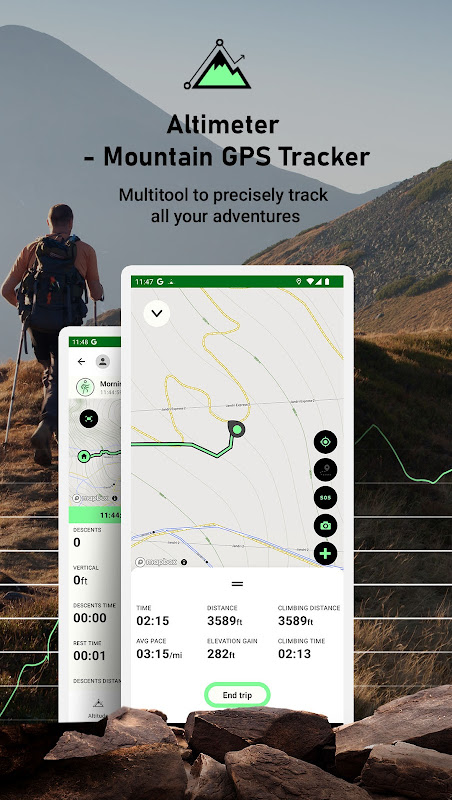
Turn your smartphone into a multi-functioned altimeter. Our unique algorithms determine your elevation using three sources - the GPS system in your phone, network services, and when available, your device’s barometer. Our algorithm combines data from all three sources to give you the most accurate reading possible.
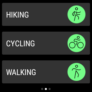
Our app comes with a brand new independent application for Wear OS watch devices. You can easily track your hiking without using your phone and synchronize data afterwards to enjoy viewing your routes on a bigger screen!
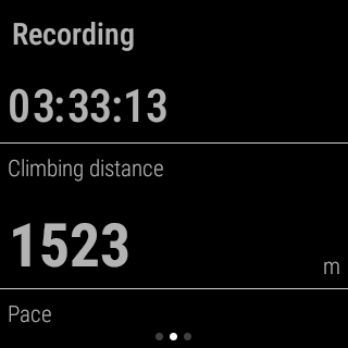
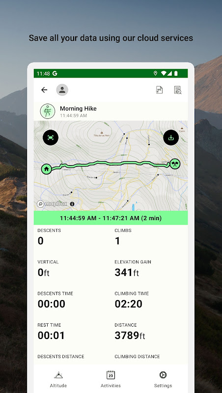
Know your exact heading on your current route, view your current position on the map and use the app to track any route you choose. The app tracks, follows and displays your route in real time, displays it and then draws elevation and speed charts during your trip. Kick back in your favorite chair after a long trip and view all of the adventures you’ve been on, our app automatically saves all of them in our database.
Tap or move your finger on or over any value on the chart to know when and where a particular value occurred. You can also choose from multiple functions such as speedometer, calorie counter, checkpoint times, notification sounds at preset milestones, and even auto pause should you decide to stop somewhere for coffee or to take a photo. If you do stop to take photos, they can easily be added with the data of your current position overplayed right on top! Your photos will have elevation, average speed, location info right on them!
Our app will also save all data associated with your account so that, should you choose to switch smartphones, nothing will be lost. Simply log in with the new device and pick up where you left off.
One of the coolest features of the app is that it divides your route into segments. In the segments screen you can see separate uphill/downhill data, you can easily check how long it took you to climb a mountain, your recent pace and elevation gain or how fast you went downhill later on. You can go into the details of the segment on the map, see a full chart and all data displayed on a list.
If you want to see your route in Maps or another application you can easily export track data to following formats:
- GPX
- KML
- KMZ
Terms and conditions: https://mysticmobileapps.com/legal/terms/altimeter.html
Privacy policy: https://mysticmobileapps.com/legal/privacy/altimeter.html
Overview
Altimeter Mountain GPS Tracker is a comprehensive mobile application designed to provide accurate altitude, GPS tracking, and route navigation for outdoor enthusiasts. Its intuitive interface and advanced features make it an indispensable tool for hikers, climbers, skiers, and other adventurers.
Key Features
* Accurate Altimeter: The app utilizes the device's built-in barometer to provide precise altitude measurements. It automatically calibrates itself based on GPS data, ensuring reliable readings even in remote areas.
* GPS Tracking: Altimeter Mountain GPS Tracker records your location and altitude data throughout your activity. It creates detailed tracks that can be saved, shared, or exported for analysis.
* Route Navigation: The app allows you to plan and follow routes using its extensive map database. It provides turn-by-turn directions, elevation profiles, and real-time progress updates.
* Weather Forecasting: The app integrates with weather services to provide up-to-date forecasts for your current location. It displays temperature, wind speed, precipitation, and other relevant information.
* Terrain Analysis: Altimeter Mountain GPS Tracker includes detailed topographic maps that provide insight into the terrain you're navigating. It highlights elevation changes, slopes, and potential hazards.
* Data Export and Sharing: The app allows you to export your recorded tracks and waypoints in various formats, including GPX, KML, and CSV. You can easily share your adventures with friends, family, or online communities.
* Offline Maps: The app can store offline maps for use in areas without internet connectivity. This ensures seamless navigation and access to altitude data even in remote locations.
Benefits
* Enhanced Safety: Accurate altitude measurements and GPS tracking provide peace of mind in unfamiliar terrain.
* Detailed Tracking: The app's comprehensive tracking capabilities allow you to analyze your performance, identify patterns, and improve your outdoor skills.
* Informed Navigation: Route navigation with elevation profiles and weather forecasting helps you make informed decisions and stay on track.
* Terrain Awareness: Detailed topographic maps provide valuable information about the terrain you're navigating, minimizing the risk of accidents or getting lost.
* Adventure Sharing: The ability to export and share your recorded tracks and waypoints allows you to connect with others and relive your outdoor experiences.
Conclusion
Altimeter Mountain GPS Tracker is an indispensable tool for outdoor enthusiasts seeking reliable altitude measurements, comprehensive GPS tracking, and advanced route navigation features. Its intuitive interface, accurate data, and robust capabilities make it an essential companion for any adventure in the mountains or beyond.
Turn your smartphone into a multi-functioned altimeter. Our unique algorithms determine your elevation using three sources - the GPS system in your phone, network services, and when available, your device’s barometer. Our algorithm combines data from all three sources to give you the most accurate reading possible.
Our app comes with a brand new independent application for Wear OS watch devices. You can easily track your hiking without using your phone and synchronize data afterwards to enjoy viewing your routes on a bigger screen!
Know your exact heading on your current route, view your current position on the map and use the app to track any route you choose. The app tracks, follows and displays your route in real time, displays it and then draws elevation and speed charts during your trip. Kick back in your favorite chair after a long trip and view all of the adventures you’ve been on, our app automatically saves all of them in our database.
Tap or move your finger on or over any value on the chart to know when and where a particular value occurred. You can also choose from multiple functions such as speedometer, calorie counter, checkpoint times, notification sounds at preset milestones, and even auto pause should you decide to stop somewhere for coffee or to take a photo. If you do stop to take photos, they can easily be added with the data of your current position overplayed right on top! Your photos will have elevation, average speed, location info right on them!
Our app will also save all data associated with your account so that, should you choose to switch smartphones, nothing will be lost. Simply log in with the new device and pick up where you left off.
One of the coolest features of the app is that it divides your route into segments. In the segments screen you can see separate uphill/downhill data, you can easily check how long it took you to climb a mountain, your recent pace and elevation gain or how fast you went downhill later on. You can go into the details of the segment on the map, see a full chart and all data displayed on a list.
If you want to see your route in Maps or another application you can easily export track data to following formats:
- GPX
- KML
- KMZ
Terms and conditions: https://mysticmobileapps.com/legal/terms/altimeter.html
Privacy policy: https://mysticmobileapps.com/legal/privacy/altimeter.html
Overview
Altimeter Mountain GPS Tracker is a comprehensive mobile application designed to provide accurate altitude, GPS tracking, and route navigation for outdoor enthusiasts. Its intuitive interface and advanced features make it an indispensable tool for hikers, climbers, skiers, and other adventurers.
Key Features
* Accurate Altimeter: The app utilizes the device's built-in barometer to provide precise altitude measurements. It automatically calibrates itself based on GPS data, ensuring reliable readings even in remote areas.
* GPS Tracking: Altimeter Mountain GPS Tracker records your location and altitude data throughout your activity. It creates detailed tracks that can be saved, shared, or exported for analysis.
* Route Navigation: The app allows you to plan and follow routes using its extensive map database. It provides turn-by-turn directions, elevation profiles, and real-time progress updates.
* Weather Forecasting: The app integrates with weather services to provide up-to-date forecasts for your current location. It displays temperature, wind speed, precipitation, and other relevant information.
* Terrain Analysis: Altimeter Mountain GPS Tracker includes detailed topographic maps that provide insight into the terrain you're navigating. It highlights elevation changes, slopes, and potential hazards.
* Data Export and Sharing: The app allows you to export your recorded tracks and waypoints in various formats, including GPX, KML, and CSV. You can easily share your adventures with friends, family, or online communities.
* Offline Maps: The app can store offline maps for use in areas without internet connectivity. This ensures seamless navigation and access to altitude data even in remote locations.
Benefits
* Enhanced Safety: Accurate altitude measurements and GPS tracking provide peace of mind in unfamiliar terrain.
* Detailed Tracking: The app's comprehensive tracking capabilities allow you to analyze your performance, identify patterns, and improve your outdoor skills.
* Informed Navigation: Route navigation with elevation profiles and weather forecasting helps you make informed decisions and stay on track.
* Terrain Awareness: Detailed topographic maps provide valuable information about the terrain you're navigating, minimizing the risk of accidents or getting lost.
* Adventure Sharing: The ability to export and share your recorded tracks and waypoints allows you to connect with others and relive your outdoor experiences.
Conclusion
Altimeter Mountain GPS Tracker is an indispensable tool for outdoor enthusiasts seeking reliable altitude measurements, comprehensive GPS tracking, and advanced route navigation features. Its intuitive interface, accurate data, and robust capabilities make it an essential companion for any adventure in the mountains or beyond.


