


Instantly compare your travel options in real-time across all transport modes globally!
Easily navigate your city with turn-by-turn directions for all your public transport, walking, cycling and scooter trips.
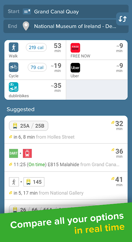
Find the best route
► Simple travel planner combining all transport modes: bus 🚎 train 🚄 tram 🚋 taxi 🚕 ride share 🚖 car share 🚗 bike share 🚲 and walking🚶♂️Discover routes you never knew existed🕵️♀️
Get real-time data for all transport rides
► TFI journey planner with all Dublin bus times, train times, and the TFI network map. Detailed directions on the LUAS tram, DART rail & local bus networks. Move around Dublin like a pro 💪
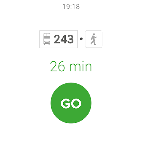
Hit the GO button for step-by-step directions
► Turn-by-turn navigation for all your public transport, walking, cycling and scooter trips. Choose between 3 different map views, see the charge levels of e-bikes around you, we even help you avoid no-parking zones. We take care of the logistical thinking so you are free to enjoy the ride 🙌
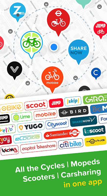
Experience one-stop-shop mobility
► Compare cab fares, hail a ride, grab the closest carshare, hop on a shared bike all from within the app. Our partners include: Uber, FREE NOW, DublinBikes 🚖 🚲
Beat the rush-hour crowd
► Live wait times and ETA so you'll never miss a bus, train or tram again. See the best carriage to board, get alerted when it's time to get off, get in and out from the best exit at any underground / train station ⏰
Smarten up your daily travel
► Get daily updates about your morning or evening commute right on your lock screen with real-time bus, DART, train and LUAS times 🚨
Personalise your city
► Save Home, Work and your go-to stops / stations for lightning fast trip planning. Subscribe to your favourite transport lines and get automatic delay/disruption alerts ❤️
Get social
► Share your live trip: let friends follow your live trip to know when you'll arrive. Share any location or address: one tap for others to get directions 🤳
Travel offline
► Access offline the official TFI network maps 🗺
City coverage
► Dublin | London | Birmingham | Manchester | Liverpool | Edinburgh | Paris | New York City | Hong Kong | Singapore | Barcelona | Moscow | Los Angeles | Berlin | Rome | Madrid | Hamburg | Milan | Stockholm | Chicago | Toronto | Sydney
+Many more worldwide! See the full list and vote for the next one in the app at: https://citymapper.com/cities 🏙
Public Transport agencies► We use open data from transport agencies in the cities we cover which includes:
Dublin | TFI (Transport for Ireland), NTA (National Transport Authority), Bus Éireann, Dublin Bus, Iarnród Éireann (Irish Rail)
Keep in touch
► If you have questions, feedback or something we may have missed in your city: email us at [email protected]📱
Like us on Facebook: http://facebook.com/thecitymapper
Follow us on Twitter: http://twitter.com/Citymapper
Visit our Website: http://citymapper.com
Citymapper is a comprehensive mobile application that revolutionizes urban navigation by seamlessly integrating various modes of transportation into a single, user-friendly platform. Its intuitive interface and real-time data empower users to plan and execute their journeys with ease and efficiency, whether they're navigating bustling metropolises or exploring unfamiliar cities.
Multimodal Navigation:
Citymapper's standout feature is its ability to provide multimodal navigation, offering users a comprehensive overview of all available transportation options. Whether it's public transit, ride-hailing services, bike-sharing programs, or walking, Citymapper presents all relevant options in a clear and concise manner, allowing users to make informed decisions based on their preferences and circumstances.
Real-Time Updates:
Citymapper stays abreast of the ever-changing urban landscape by providing real-time updates on traffic conditions, transit schedules, and service disruptions. This invaluable information ensures that users are always aware of potential delays or detours, empowering them to adjust their routes accordingly and avoid unnecessary hassles.
Personalized Recommendations:
Citymapper goes beyond simply providing navigation; it also offers personalized recommendations tailored to the user's preferences and past travel patterns. By learning from user behavior, Citymapper can suggest optimal routes, predict travel times, and even provide customized alerts for upcoming journeys. This level of personalization enhances the user experience, making navigation more efficient and convenient.
Accessibility and Inclusivity:
Citymapper is committed to accessibility and inclusivity, ensuring that its services are available to all users regardless of their abilities or circumstances. The app features a range of accessibility options, including voice guidance, high-contrast mode, and wheelchair-accessible route planning. This inclusive approach empowers everyone to navigate urban environments with confidence and ease.
Integration with Other Services:
Citymapper seamlessly integrates with a wide range of other services, further enhancing its utility and convenience. Users can purchase transit tickets directly within the app, connect their Apple Watch for quick access to directions, and even share their live location with friends and family for peace of mind.
Conclusion:
Citymapper is the ultimate urban navigation tool, empowering users to navigate complex urban environments with ease, efficiency, and confidence. Its multimodal navigation, real-time updates, personalized recommendations, accessibility options, and seamless integration with other services make it an indispensable companion for anyone seeking to explore and conquer the urban jungle.
Instantly compare your travel options in real-time across all transport modes globally!
Easily navigate your city with turn-by-turn directions for all your public transport, walking, cycling and scooter trips.
Find the best route
► Simple travel planner combining all transport modes: bus 🚎 train 🚄 tram 🚋 taxi 🚕 ride share 🚖 car share 🚗 bike share 🚲 and walking🚶♂️Discover routes you never knew existed🕵️♀️
Get real-time data for all transport rides
► TFI journey planner with all Dublin bus times, train times, and the TFI network map. Detailed directions on the LUAS tram, DART rail & local bus networks. Move around Dublin like a pro 💪
Hit the GO button for step-by-step directions
► Turn-by-turn navigation for all your public transport, walking, cycling and scooter trips. Choose between 3 different map views, see the charge levels of e-bikes around you, we even help you avoid no-parking zones. We take care of the logistical thinking so you are free to enjoy the ride 🙌
Experience one-stop-shop mobility
► Compare cab fares, hail a ride, grab the closest carshare, hop on a shared bike all from within the app. Our partners include: Uber, FREE NOW, DublinBikes 🚖 🚲
Beat the rush-hour crowd
► Live wait times and ETA so you'll never miss a bus, train or tram again. See the best carriage to board, get alerted when it's time to get off, get in and out from the best exit at any underground / train station ⏰
Smarten up your daily travel
► Get daily updates about your morning or evening commute right on your lock screen with real-time bus, DART, train and LUAS times 🚨
Personalise your city
► Save Home, Work and your go-to stops / stations for lightning fast trip planning. Subscribe to your favourite transport lines and get automatic delay/disruption alerts ❤️
Get social
► Share your live trip: let friends follow your live trip to know when you'll arrive. Share any location or address: one tap for others to get directions 🤳
Travel offline
► Access offline the official TFI network maps 🗺
City coverage
► Dublin | London | Birmingham | Manchester | Liverpool | Edinburgh | Paris | New York City | Hong Kong | Singapore | Barcelona | Moscow | Los Angeles | Berlin | Rome | Madrid | Hamburg | Milan | Stockholm | Chicago | Toronto | Sydney
+Many more worldwide! See the full list and vote for the next one in the app at: https://citymapper.com/cities 🏙
Public Transport agencies► We use open data from transport agencies in the cities we cover which includes:
Dublin | TFI (Transport for Ireland), NTA (National Transport Authority), Bus Éireann, Dublin Bus, Iarnród Éireann (Irish Rail)
Keep in touch
► If you have questions, feedback or something we may have missed in your city: email us at [email protected]📱
Like us on Facebook: http://facebook.com/thecitymapper
Follow us on Twitter: http://twitter.com/Citymapper
Visit our Website: http://citymapper.com
Citymapper is a comprehensive mobile application that revolutionizes urban navigation by seamlessly integrating various modes of transportation into a single, user-friendly platform. Its intuitive interface and real-time data empower users to plan and execute their journeys with ease and efficiency, whether they're navigating bustling metropolises or exploring unfamiliar cities.
Multimodal Navigation:
Citymapper's standout feature is its ability to provide multimodal navigation, offering users a comprehensive overview of all available transportation options. Whether it's public transit, ride-hailing services, bike-sharing programs, or walking, Citymapper presents all relevant options in a clear and concise manner, allowing users to make informed decisions based on their preferences and circumstances.
Real-Time Updates:
Citymapper stays abreast of the ever-changing urban landscape by providing real-time updates on traffic conditions, transit schedules, and service disruptions. This invaluable information ensures that users are always aware of potential delays or detours, empowering them to adjust their routes accordingly and avoid unnecessary hassles.
Personalized Recommendations:
Citymapper goes beyond simply providing navigation; it also offers personalized recommendations tailored to the user's preferences and past travel patterns. By learning from user behavior, Citymapper can suggest optimal routes, predict travel times, and even provide customized alerts for upcoming journeys. This level of personalization enhances the user experience, making navigation more efficient and convenient.
Accessibility and Inclusivity:
Citymapper is committed to accessibility and inclusivity, ensuring that its services are available to all users regardless of their abilities or circumstances. The app features a range of accessibility options, including voice guidance, high-contrast mode, and wheelchair-accessible route planning. This inclusive approach empowers everyone to navigate urban environments with confidence and ease.
Integration with Other Services:
Citymapper seamlessly integrates with a wide range of other services, further enhancing its utility and convenience. Users can purchase transit tickets directly within the app, connect their Apple Watch for quick access to directions, and even share their live location with friends and family for peace of mind.
Conclusion:
Citymapper is the ultimate urban navigation tool, empowering users to navigate complex urban environments with ease, efficiency, and confidence. Its multimodal navigation, real-time updates, personalized recommendations, accessibility options, and seamless integration with other services make it an indispensable companion for anyone seeking to explore and conquer the urban jungle.


