

Welcome to the most detailed travel guide for overland travel in Africa. This offline app offers a great map and huge amount of detailed places of interest for planning your next safari. Your GPS location will ensure you stay orientated while using the app on your self-drive trip.
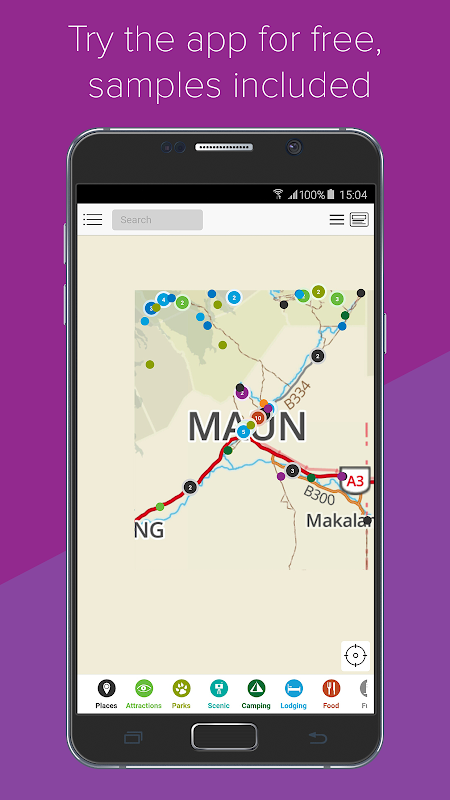
Try it out for free
The free app contains samples of the map and guide information. If you like what you see, go to in-app purchases and get the full app functionality of the country that you want.
How does it work?
This is not a routing/navigation app. The app aims to bring you offline access (i.e. no internet connection required) to the following:
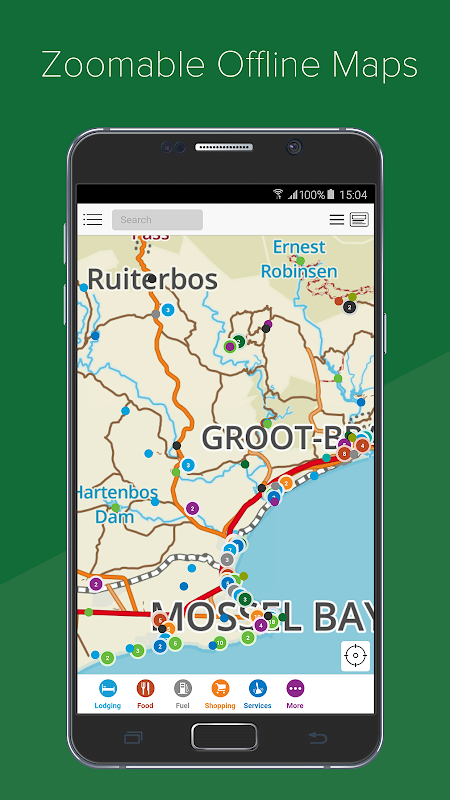
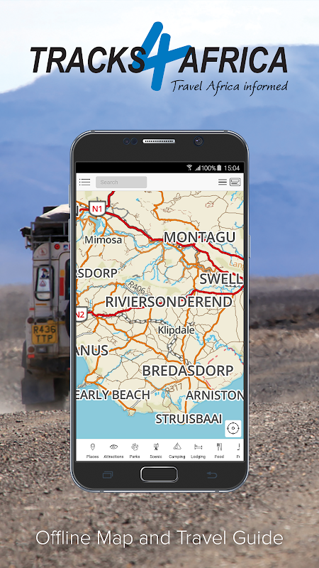
• A detailed map of the country or region you purchase. The country map roughly corresponds to a 1:1 000 000 paper map in terms of its detail and will allow you to view the map at different zoom levels. The map works similar to a web map with the difference being that all information is installed on your device. It contains place names like cities, towns and villages together with a detailed road and track network. It also shows you all protected areas such as national parks and game reserves together with relevant background data such as rivers, mountains and major attractions.
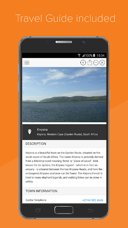
• A detailed guide with the following categories: Places (cities, towns, etc), Attractions & Activities, Parks, Scenic, Camps, Lodging, Food & Drink, Fuel, Shopping, Services and More (miscellaneous points of interest). The guide information is linked to a location on the map and will display as a pin on the map for you to know where it is in reference to where you are.
The app will display a map of the country or region and allow you to switch on different categories of points of interest. You can also search for specific places by name. The map search is location sensitive, i.e. results will be relative to the centre of the map.
Your position, determined from your Android phone or tablet's location service, will display on the map so you can accurately orientate yourself on the map. As you drive, your location will update on the map so you always know where you are. (Device with GPS required)
The search functionality is linked to the guide categories. For example, if you need to find a campsite, simply switch on the Camps category. Immediately all campsites around you will display on the map and you can click on them for more information. Otherwise, if you know the name of a campsite, enter it into the search block and relevant results will be filtered.
What kind of information can you expect?
Apart from the categories already mentioned, points of interest will have associated information such as a description, contacts details, facilities and activities and some places will have photos. Have a look at the sample data in the free app to get an idea of what we offer.
What about updates?
The guides are sold according to year e.g. Namibia 2016 edition. We will provide free updates for one year after it has been replaced by a new edition. In other words, if you buy the 2016 edition, you will receive updates throughout 2016 and 2017. You can obviously continue to use your guide for as long as you want, it does not expire - just like a book.
Space required for offline guides?
369 MB South Africa
196 MB Angola to Mozambique
172 MB East Africa
143 MB Namibia
114 MB West Africa
99 MB North Africa
74 MB Central Africa
62 MB Botswana
32 MB Indian Ocean Islands
Further developments
This is a brand new product and we envisage that it will develop new features over time. Remember, Africa was not travelled in one day.
Talk to us
We sincerely would like to hear what you think of the app. If you place a comment, question or suggestion in the review section, we cannot reply to you. So please drop us a line so we can engage and learn what you would like to see in subsequent releases of our app. You can contact us at [email protected] or via our Facebook page: facebook.com/Tracks4Africa.
Tracks4Africa Guide is a comprehensive digital mapping and navigation system specifically designed for adventure travelers exploring Africa. It provides detailed, accurate, and up-to-date maps, tracks, and points of interest for over 100 countries across the continent.
Key Features:
* Extensive Map Coverage: Tracks4Africa Guide covers a vast majority of Africa, including remote areas, national parks, and off-road trails.
* Detailed Tracks: The guide includes a vast database of user-generated and verified tracks, providing routes for all types of vehicles, including 4x4s, motorcycles, and bicycles.
* Points of Interest (POIs): The guide offers an extensive list of POIs, including campsites, lodges, fuel stations, border crossings, and cultural landmarks.
* Offline Navigation: Maps and data can be downloaded for offline use, ensuring reliable navigation even in areas with limited or no internet connectivity.
* GPS Tracking: Tracks4Africa Guide allows users to track their progress, record their own tracks, and share them with others.
* Trip Planning Tools: The guide includes trip planning tools to help users create customized itineraries, calculate distances, and find suitable accommodations.
* User-Generated Content: Tracks4Africa Guide is continuously updated with user-generated content, ensuring the most up-to-date information and feedback from the community.
Benefits:
* Enhanced Safety: Accurate maps and navigation capabilities provide peace of mind and reduce the risk of getting lost or stranded.
* Optimized Planning: Trip planning tools help travelers optimize their itineraries and avoid unexpected challenges.
* Unforgettable Experiences: Tracks4Africa Guide unlocks access to remote and lesser-known destinations, enabling travelers to experience the true beauty of Africa.
* Community Connection: The user-generated content platform fosters a sense of community among adventure travelers and provides valuable insights and recommendations.
Compatibility:
Tracks4Africa Guide is compatible with a wide range of GPS devices, smartphones, and tablets. It can be used as a standalone navigation system or integrated with other navigation apps.
Conclusion:
Tracks4Africa Guide is an indispensable tool for anyone planning an adventure trip in Africa. Its comprehensive maps, tracks, POIs, offline navigation capabilities, and user-generated content provide the information and guidance necessary to explore the continent safely, efficiently, and with confidence.
Welcome to the most detailed travel guide for overland travel in Africa. This offline app offers a great map and huge amount of detailed places of interest for planning your next safari. Your GPS location will ensure you stay orientated while using the app on your self-drive trip.
Try it out for free
The free app contains samples of the map and guide information. If you like what you see, go to in-app purchases and get the full app functionality of the country that you want.
How does it work?
This is not a routing/navigation app. The app aims to bring you offline access (i.e. no internet connection required) to the following:
• A detailed map of the country or region you purchase. The country map roughly corresponds to a 1:1 000 000 paper map in terms of its detail and will allow you to view the map at different zoom levels. The map works similar to a web map with the difference being that all information is installed on your device. It contains place names like cities, towns and villages together with a detailed road and track network. It also shows you all protected areas such as national parks and game reserves together with relevant background data such as rivers, mountains and major attractions.
• A detailed guide with the following categories: Places (cities, towns, etc), Attractions & Activities, Parks, Scenic, Camps, Lodging, Food & Drink, Fuel, Shopping, Services and More (miscellaneous points of interest). The guide information is linked to a location on the map and will display as a pin on the map for you to know where it is in reference to where you are.
The app will display a map of the country or region and allow you to switch on different categories of points of interest. You can also search for specific places by name. The map search is location sensitive, i.e. results will be relative to the centre of the map.
Your position, determined from your Android phone or tablet's location service, will display on the map so you can accurately orientate yourself on the map. As you drive, your location will update on the map so you always know where you are. (Device with GPS required)
The search functionality is linked to the guide categories. For example, if you need to find a campsite, simply switch on the Camps category. Immediately all campsites around you will display on the map and you can click on them for more information. Otherwise, if you know the name of a campsite, enter it into the search block and relevant results will be filtered.
What kind of information can you expect?
Apart from the categories already mentioned, points of interest will have associated information such as a description, contacts details, facilities and activities and some places will have photos. Have a look at the sample data in the free app to get an idea of what we offer.
What about updates?
The guides are sold according to year e.g. Namibia 2016 edition. We will provide free updates for one year after it has been replaced by a new edition. In other words, if you buy the 2016 edition, you will receive updates throughout 2016 and 2017. You can obviously continue to use your guide for as long as you want, it does not expire - just like a book.
Space required for offline guides?
369 MB South Africa
196 MB Angola to Mozambique
172 MB East Africa
143 MB Namibia
114 MB West Africa
99 MB North Africa
74 MB Central Africa
62 MB Botswana
32 MB Indian Ocean Islands
Further developments
This is a brand new product and we envisage that it will develop new features over time. Remember, Africa was not travelled in one day.
Talk to us
We sincerely would like to hear what you think of the app. If you place a comment, question or suggestion in the review section, we cannot reply to you. So please drop us a line so we can engage and learn what you would like to see in subsequent releases of our app. You can contact us at [email protected] or via our Facebook page: facebook.com/Tracks4Africa.
Tracks4Africa Guide is a comprehensive digital mapping and navigation system specifically designed for adventure travelers exploring Africa. It provides detailed, accurate, and up-to-date maps, tracks, and points of interest for over 100 countries across the continent.
Key Features:
* Extensive Map Coverage: Tracks4Africa Guide covers a vast majority of Africa, including remote areas, national parks, and off-road trails.
* Detailed Tracks: The guide includes a vast database of user-generated and verified tracks, providing routes for all types of vehicles, including 4x4s, motorcycles, and bicycles.
* Points of Interest (POIs): The guide offers an extensive list of POIs, including campsites, lodges, fuel stations, border crossings, and cultural landmarks.
* Offline Navigation: Maps and data can be downloaded for offline use, ensuring reliable navigation even in areas with limited or no internet connectivity.
* GPS Tracking: Tracks4Africa Guide allows users to track their progress, record their own tracks, and share them with others.
* Trip Planning Tools: The guide includes trip planning tools to help users create customized itineraries, calculate distances, and find suitable accommodations.
* User-Generated Content: Tracks4Africa Guide is continuously updated with user-generated content, ensuring the most up-to-date information and feedback from the community.
Benefits:
* Enhanced Safety: Accurate maps and navigation capabilities provide peace of mind and reduce the risk of getting lost or stranded.
* Optimized Planning: Trip planning tools help travelers optimize their itineraries and avoid unexpected challenges.
* Unforgettable Experiences: Tracks4Africa Guide unlocks access to remote and lesser-known destinations, enabling travelers to experience the true beauty of Africa.
* Community Connection: The user-generated content platform fosters a sense of community among adventure travelers and provides valuable insights and recommendations.
Compatibility:
Tracks4Africa Guide is compatible with a wide range of GPS devices, smartphones, and tablets. It can be used as a standalone navigation system or integrated with other navigation apps.
Conclusion:
Tracks4Africa Guide is an indispensable tool for anyone planning an adventure trip in Africa. Its comprehensive maps, tracks, POIs, offline navigation capabilities, and user-generated content provide the information and guidance necessary to explore the continent safely, efficiently, and with confidence.


