


We guide you on your hike - from planning your tour to precise navigation.
The bergfex: hiking & tracking app is a must-have for every hike, ski tour or other outdoor activity.
Find the most beautiful hiking trails in your area or create personal tours with our route planner and track all your outdoor activities. Precise GPS navigation, detailed hiking maps for the entire Alpine region and other useful features bring you safely to your destination.
Get to know the bergfex hiking app for free!
Find hikes or ski tours that suit you
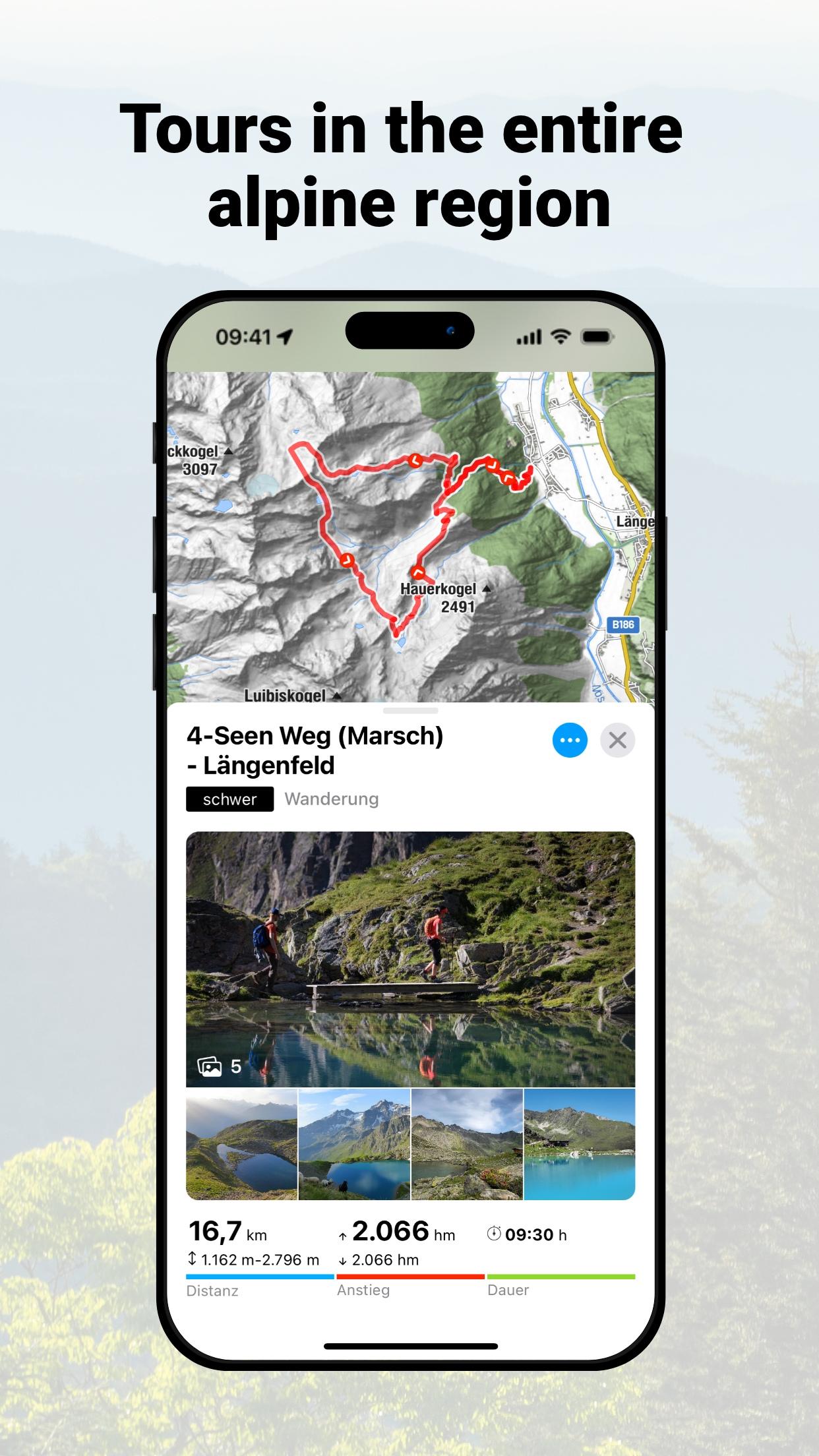
The bergfex tours app contains around 200,000 hiking trails, ski tours, running routes and mountain bike trails throughout Europe. Detailed tour descriptions, topographic hiking maps for the entire Alpine region and filter options make it easy to find the ideal tour.
Tour planner and hiking navigation
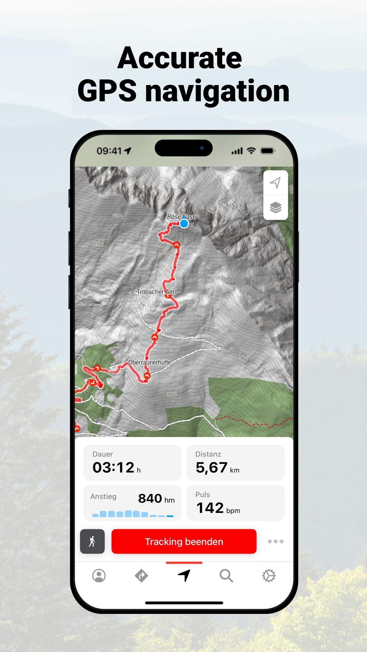
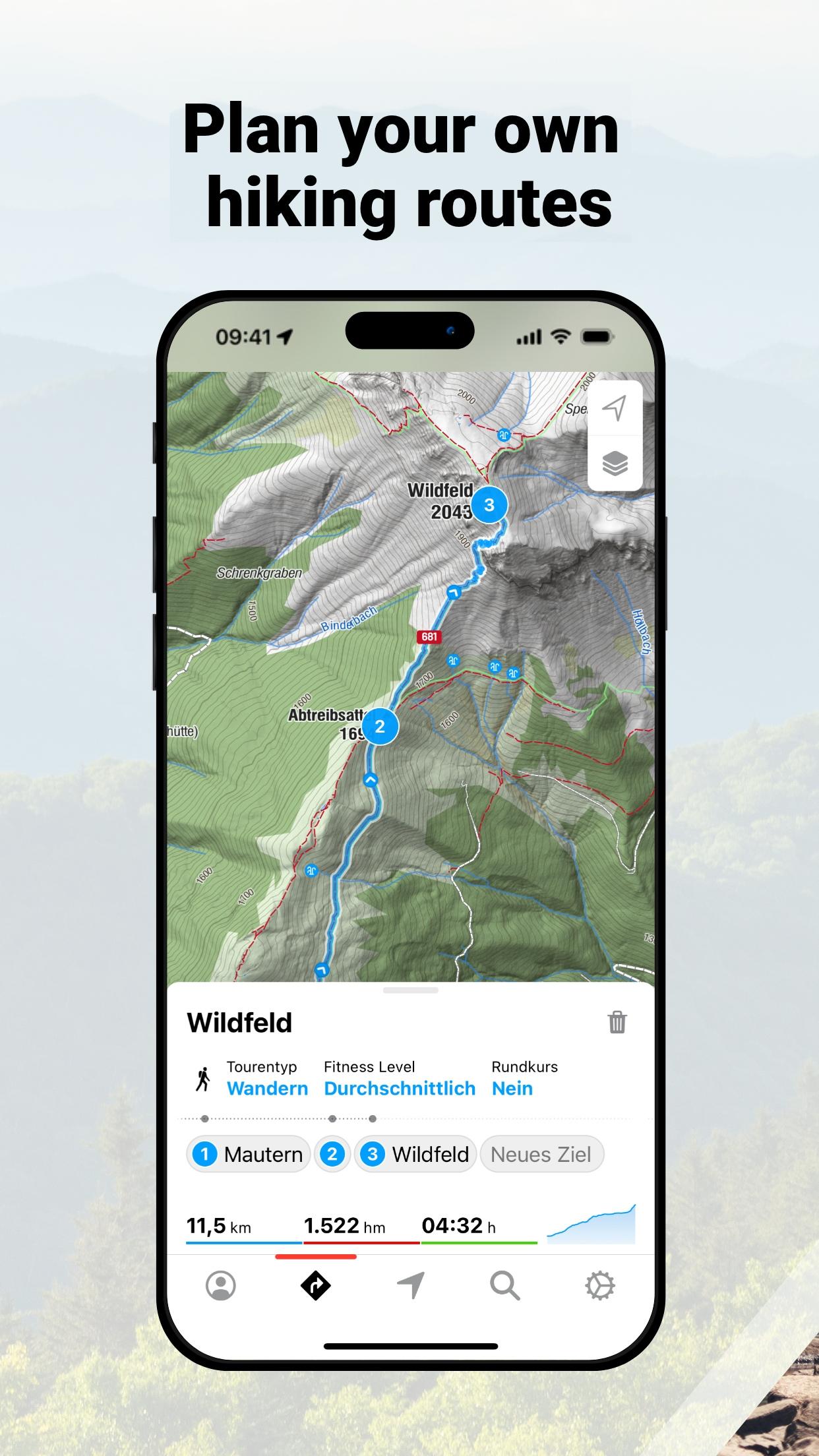
You haven't found the perfect hiking or ski tour yet? Then use the bergfex tour planner. In just a few steps you can create your personal hike and let it navigate you to the summit. The precise GPS hiking navigator won't let you down even in the mountains.
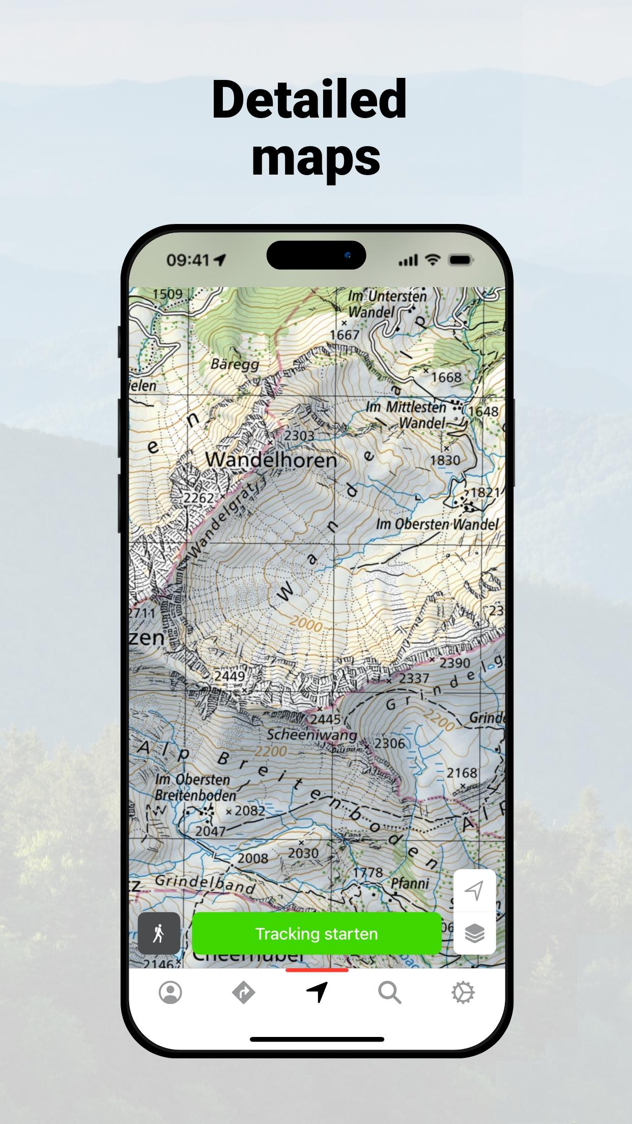
Detailed maps
Our maps for the entire European Alpine region come from OpenStreetMap (OSM). This means that when planning your route and while hiking, you can be sure that you will find the right route thanks to regularly updated maps.
Tracking hiking routes and trails
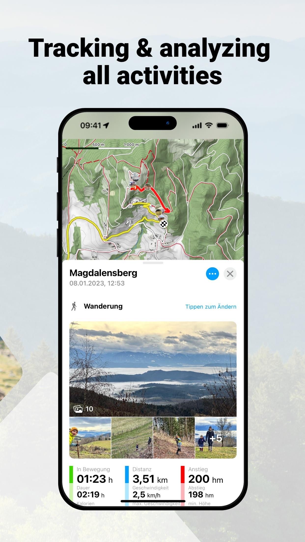
Track the distance covered while hiking, ski touring, running or mountain biking and get comprehensive statistics such as duration, altitude metres, elevation profile, distance and speed. A heat map shows you all the activities you have recorded so far.
Route and fitness tracking combined
Keep track of your fitness level and activities! Optionally, you can wear a Bluetooth heart rate monitor while hiking, ski touring or other sports to get even more detailed information about your fitness level.
Garmin Connect, websync and GPX-import
Your hikes and planned tours are automatically synchronised with your bergfex account. Tracked activities are also displayed in Garmin Connect and Polar Flow. Self-created routes can be exported and imported via GPX file.
_____________________
Test many pro functions for 7 days free of charge & without any commitment
Register in the hiking app and test the helpful functions of our PRO subscription on your next hike:
• more detailed map material thanks to higher zoom level
• warning signal when leaving the route
• overlay to visualise slope steepness >30°, 35°, 40°, 45°
• official hiking maps such as ÖK50, SwissMap, etc.
• offline map material for navigation even without an active internet connection
• satellite map with additional information and points of interest
• intermediate destinations for route planning
• zones for heart rate measurement
• hiking, ski touring and more without advertising
_____________________
Any questions?
If you have any questions or comments about our app, please send us an email at:
Note: Continuous GPS usage can result in a severe reduction in battery life.
Terms of use: www.bergfex.com/c/agb
Privacy: www.bergfex.com/c/datenschutz/
What's New in the Latest Version 4.16.3
Last updated on Jul 7, 2024
Having questions or problems with our app? Contact us via email:
- Improved UX
- Stability and usability improvements
One of the core features of Bergfex is its extensive trail database. Users can browse a vast selection of trails categorized by difficulty, length, elevation gain, and terrain type. Detailed trail descriptions provide valuable insights into the expected challenges and highlights of each route, including information about terrain conditions, water sources, and potential hazards. Users can also filter trails based on their preferences, such as proximity, duration, and suitability for families or pets.
The app's integrated mapping functionality allows users to visualize their chosen trails on detailed topographic maps. Users can zoom in and out to gain a better understanding of the terrain, identify potential obstacles, and plan their ascent and descent accordingly. The map also displays points of interest along the trail, such as mountain huts, viewpoints, and historical landmarks. This feature is particularly useful for navigating unfamiliar terrain and ensuring that hikers stay on course.
Bergfex also offers a robust tracking feature that allows users to record their hiking progress in real-time. As users hike, the app tracks their location, speed, elevation gain, and distance covered. This data is then displayed on the map, providing a visual representation of the user's journey. The tracking feature also allows users to share their progress with friends and family, providing peace of mind for solo hikers.
The app's offline functionality is a crucial feature for hikers venturing into areas with limited or no cellular connectivity. Users can download maps and trail information in advance, ensuring that they have access to crucial navigation data even in remote areas. This feature is essential for safety and allows hikers to explore with confidence, knowing that they have access to reliable information regardless of network availability.
Bergfex also provides up-to-date weather information for the selected hiking region. Users can access detailed forecasts, including temperature, precipitation, wind speed, and visibility. This information is crucial for planning safe and enjoyable hikes and allows users to make informed decisions about their itinerary based on current and predicted weather conditions.
The app's social features allow users to connect with other outdoor enthusiasts and share their hiking experiences. Users can create profiles, upload photos and videos, and share their completed hikes with the Bergfex community. This fosters a sense of camaraderie among hikers and provides a platform for sharing tips, recommendations, and stories.
Bergfex also integrates with other popular fitness tracking apps, allowing users to seamlessly sync their hiking data with other platforms. This feature is particularly useful for users who track their fitness progress across multiple apps and allows for a more comprehensive overview of their overall activity levels.
The app's user-friendly interface makes it easy to navigate and access the various features. The intuitive design ensures that even novice users can quickly learn how to use the app effectively. The clear and concise presentation of information makes it easy to understand and interpret the data, enhancing the overall user experience.
Bergfex: Hiking & Tracking is a valuable tool for anyone who enjoys exploring the outdoors. Its comprehensive features, combined with its user-friendly interface, make it an essential companion for hikers of all levels. Whether planning a challenging multi-day trek or a leisurely afternoon stroll, Bergfex provides the information and tools necessary to ensure a safe, enjoyable, and memorable hiking experience. From detailed trail descriptions and topographic maps to real-time tracking and offline functionality, Bergfex empowers hikers with the knowledge and resources they need to explore the mountains with confidence. The app's social features and integration with other fitness platforms further enhance its value, making it a comprehensive and versatile tool for outdoor enthusiasts.
We guide you on your hike - from planning your tour to precise navigation.
The bergfex: hiking & tracking app is a must-have for every hike, ski tour or other outdoor activity.
Find the most beautiful hiking trails in your area or create personal tours with our route planner and track all your outdoor activities. Precise GPS navigation, detailed hiking maps for the entire Alpine region and other useful features bring you safely to your destination.
Get to know the bergfex hiking app for free!
Find hikes or ski tours that suit you
The bergfex tours app contains around 200,000 hiking trails, ski tours, running routes and mountain bike trails throughout Europe. Detailed tour descriptions, topographic hiking maps for the entire Alpine region and filter options make it easy to find the ideal tour.
Tour planner and hiking navigation
You haven't found the perfect hiking or ski tour yet? Then use the bergfex tour planner. In just a few steps you can create your personal hike and let it navigate you to the summit. The precise GPS hiking navigator won't let you down even in the mountains.
Detailed maps
Our maps for the entire European Alpine region come from OpenStreetMap (OSM). This means that when planning your route and while hiking, you can be sure that you will find the right route thanks to regularly updated maps.
Tracking hiking routes and trails
Track the distance covered while hiking, ski touring, running or mountain biking and get comprehensive statistics such as duration, altitude metres, elevation profile, distance and speed. A heat map shows you all the activities you have recorded so far.
Route and fitness tracking combined
Keep track of your fitness level and activities! Optionally, you can wear a Bluetooth heart rate monitor while hiking, ski touring or other sports to get even more detailed information about your fitness level.
Garmin Connect, websync and GPX-import
Your hikes and planned tours are automatically synchronised with your bergfex account. Tracked activities are also displayed in Garmin Connect and Polar Flow. Self-created routes can be exported and imported via GPX file.
_____________________
Test many pro functions for 7 days free of charge & without any commitment
Register in the hiking app and test the helpful functions of our PRO subscription on your next hike:
• more detailed map material thanks to higher zoom level
• warning signal when leaving the route
• overlay to visualise slope steepness >30°, 35°, 40°, 45°
• official hiking maps such as ÖK50, SwissMap, etc.
• offline map material for navigation even without an active internet connection
• satellite map with additional information and points of interest
• intermediate destinations for route planning
• zones for heart rate measurement
• hiking, ski touring and more without advertising
_____________________
Any questions?
If you have any questions or comments about our app, please send us an email at:
Note: Continuous GPS usage can result in a severe reduction in battery life.
Terms of use: www.bergfex.com/c/agb
Privacy: www.bergfex.com/c/datenschutz/
What's New in the Latest Version 4.16.3
Last updated on Jul 7, 2024
Having questions or problems with our app? Contact us via email:
- Improved UX
- Stability and usability improvements
One of the core features of Bergfex is its extensive trail database. Users can browse a vast selection of trails categorized by difficulty, length, elevation gain, and terrain type. Detailed trail descriptions provide valuable insights into the expected challenges and highlights of each route, including information about terrain conditions, water sources, and potential hazards. Users can also filter trails based on their preferences, such as proximity, duration, and suitability for families or pets.
The app's integrated mapping functionality allows users to visualize their chosen trails on detailed topographic maps. Users can zoom in and out to gain a better understanding of the terrain, identify potential obstacles, and plan their ascent and descent accordingly. The map also displays points of interest along the trail, such as mountain huts, viewpoints, and historical landmarks. This feature is particularly useful for navigating unfamiliar terrain and ensuring that hikers stay on course.
Bergfex also offers a robust tracking feature that allows users to record their hiking progress in real-time. As users hike, the app tracks their location, speed, elevation gain, and distance covered. This data is then displayed on the map, providing a visual representation of the user's journey. The tracking feature also allows users to share their progress with friends and family, providing peace of mind for solo hikers.
The app's offline functionality is a crucial feature for hikers venturing into areas with limited or no cellular connectivity. Users can download maps and trail information in advance, ensuring that they have access to crucial navigation data even in remote areas. This feature is essential for safety and allows hikers to explore with confidence, knowing that they have access to reliable information regardless of network availability.
Bergfex also provides up-to-date weather information for the selected hiking region. Users can access detailed forecasts, including temperature, precipitation, wind speed, and visibility. This information is crucial for planning safe and enjoyable hikes and allows users to make informed decisions about their itinerary based on current and predicted weather conditions.
The app's social features allow users to connect with other outdoor enthusiasts and share their hiking experiences. Users can create profiles, upload photos and videos, and share their completed hikes with the Bergfex community. This fosters a sense of camaraderie among hikers and provides a platform for sharing tips, recommendations, and stories.
Bergfex also integrates with other popular fitness tracking apps, allowing users to seamlessly sync their hiking data with other platforms. This feature is particularly useful for users who track their fitness progress across multiple apps and allows for a more comprehensive overview of their overall activity levels.
The app's user-friendly interface makes it easy to navigate and access the various features. The intuitive design ensures that even novice users can quickly learn how to use the app effectively. The clear and concise presentation of information makes it easy to understand and interpret the data, enhancing the overall user experience.
Bergfex: Hiking & Tracking is a valuable tool for anyone who enjoys exploring the outdoors. Its comprehensive features, combined with its user-friendly interface, make it an essential companion for hikers of all levels. Whether planning a challenging multi-day trek or a leisurely afternoon stroll, Bergfex provides the information and tools necessary to ensure a safe, enjoyable, and memorable hiking experience. From detailed trail descriptions and topographic maps to real-time tracking and offline functionality, Bergfex empowers hikers with the knowledge and resources they need to explore the mountains with confidence. The app's social features and integration with other fitness platforms further enhance its value, making it a comprehensive and versatile tool for outdoor enthusiasts.


