

Offroad & Outdoor Navigation. Multiple Maps: Topo, Aerials, Nautical Charts, etc
Easy to use outdoor navigation app with free access to the best available maps and aerial imagery for Canada.
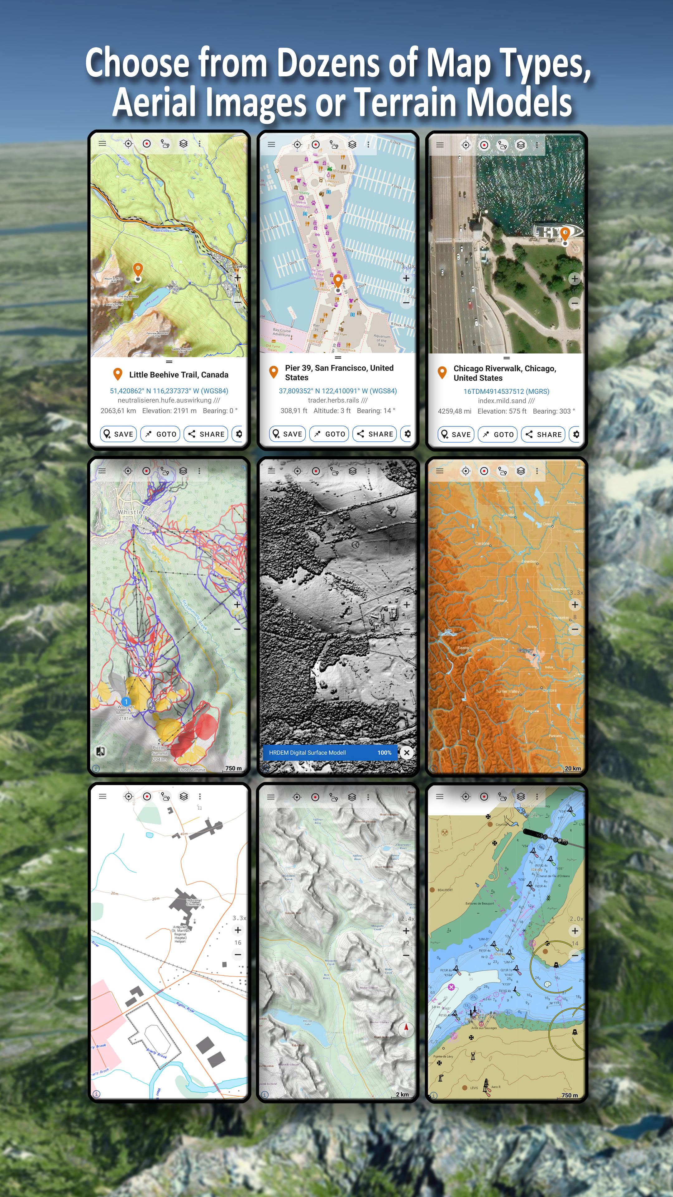
Choose between 30+ map layers (topos, aerials, sea charts, ...) to plan the perfect trip and
turn your Andoid Phone/Tablet into an outdoor GPS for offline trips into the backcountry.
*** Note: Please use Canada Base Map, Toporama or OpenStreetMap layer if you need most recent topo maps ! ***
Add easily maps from other sources (GeoPDF, GeoTiff, Online Map Services like WMS, ...)
Available base map layers for Canada:
• Topomaps Canada (CanMatrix, seamless coverage at scales 1:50.000 and 1:250.000), incl. USA 1:24.000 - 1:250.000), > 30.000 maps
• Canada Basemap CBMT (CanVec, NTDB, Atlas of Canada)
• Toporama Maps Canada in EN&FR (CanVec, NTDB, Atlas of Canada)
• CanTopo (new Canada Topos at 1:50.000, partial coverage of Canada, mainly in the North)
• Ontario LIO Topo Maps
• Québec Topo Maps 1:20.000
• Saskatchewan Orthophotos
• Nova Scotia Othophotos
• British Columbia Topo Maps
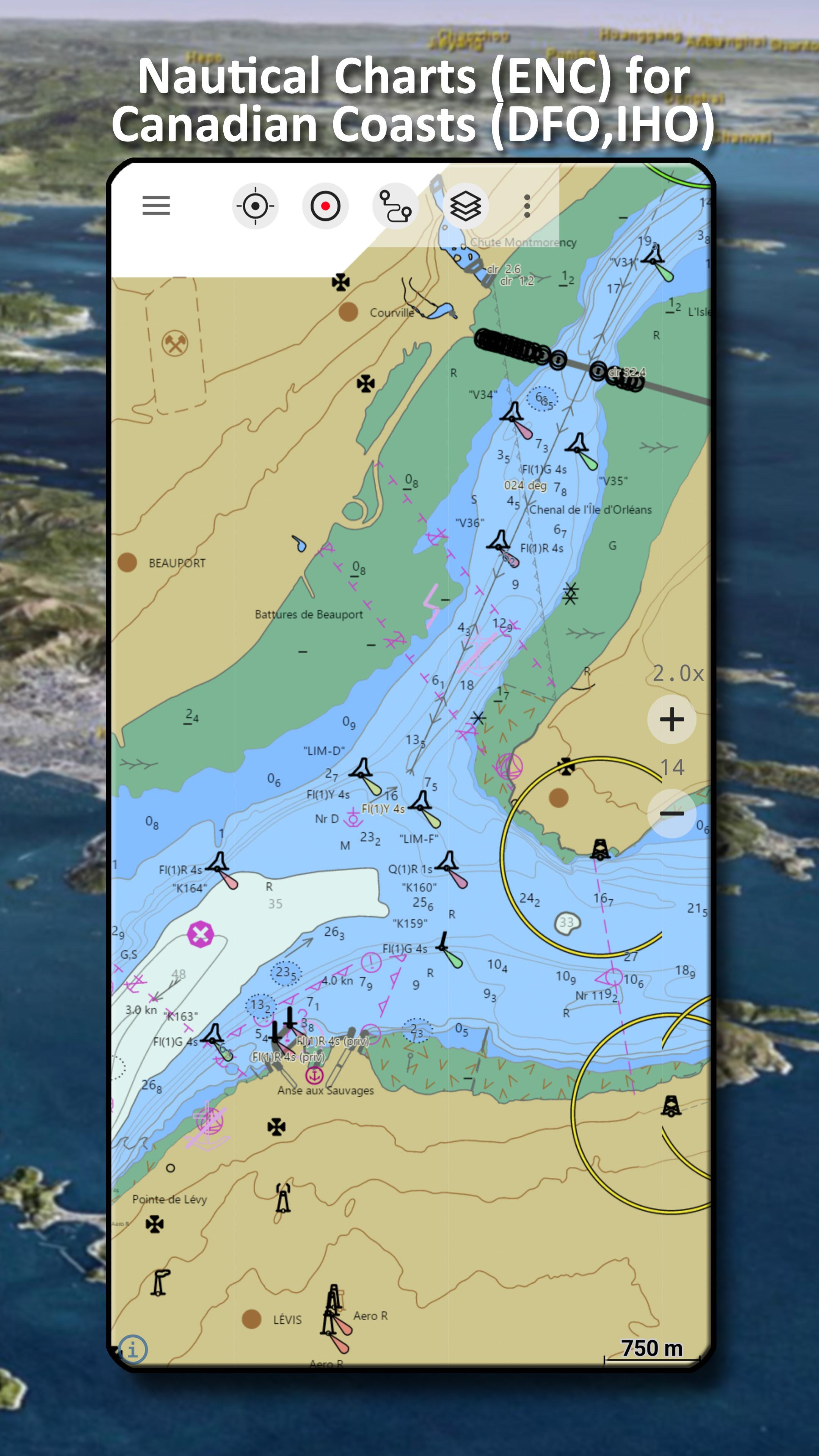
• Nautical Charts ENC
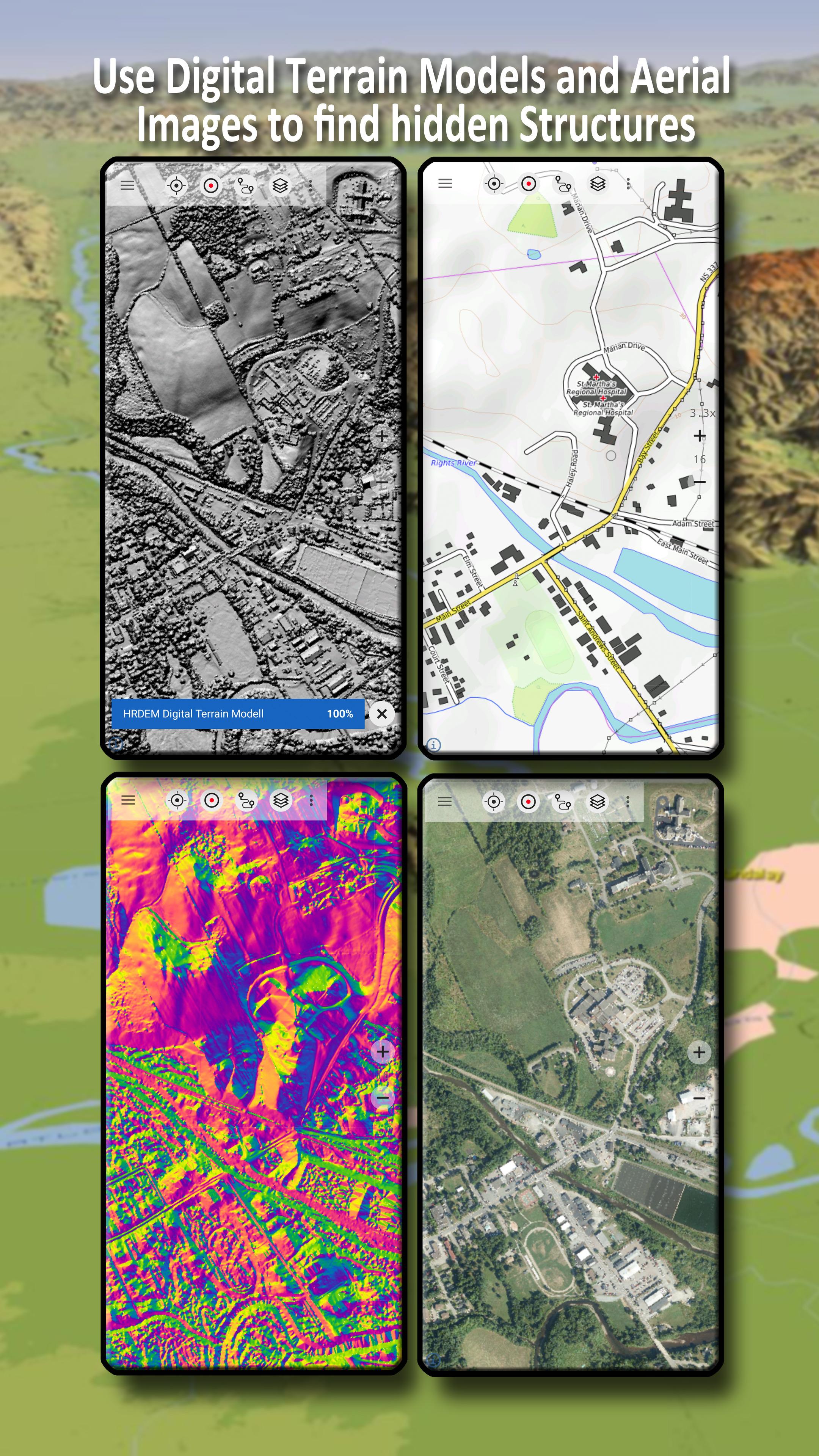
• Digital Elevation Model
• HRDEM (HiRes Elevation Model, parts of Canada)
Worldwide basemap layers:
• OpenStreetMaps (5 different map layouts), also downloadable in space saving vectorformat
• Google Maps (Satellite images, Road- and Terrain-Map)
• Bing Maps (Satellite images, Road-Map)
• ESRI Maps (Satellite images, Road- and Terrain-Map)
• Waze Roads
• Earth At Night
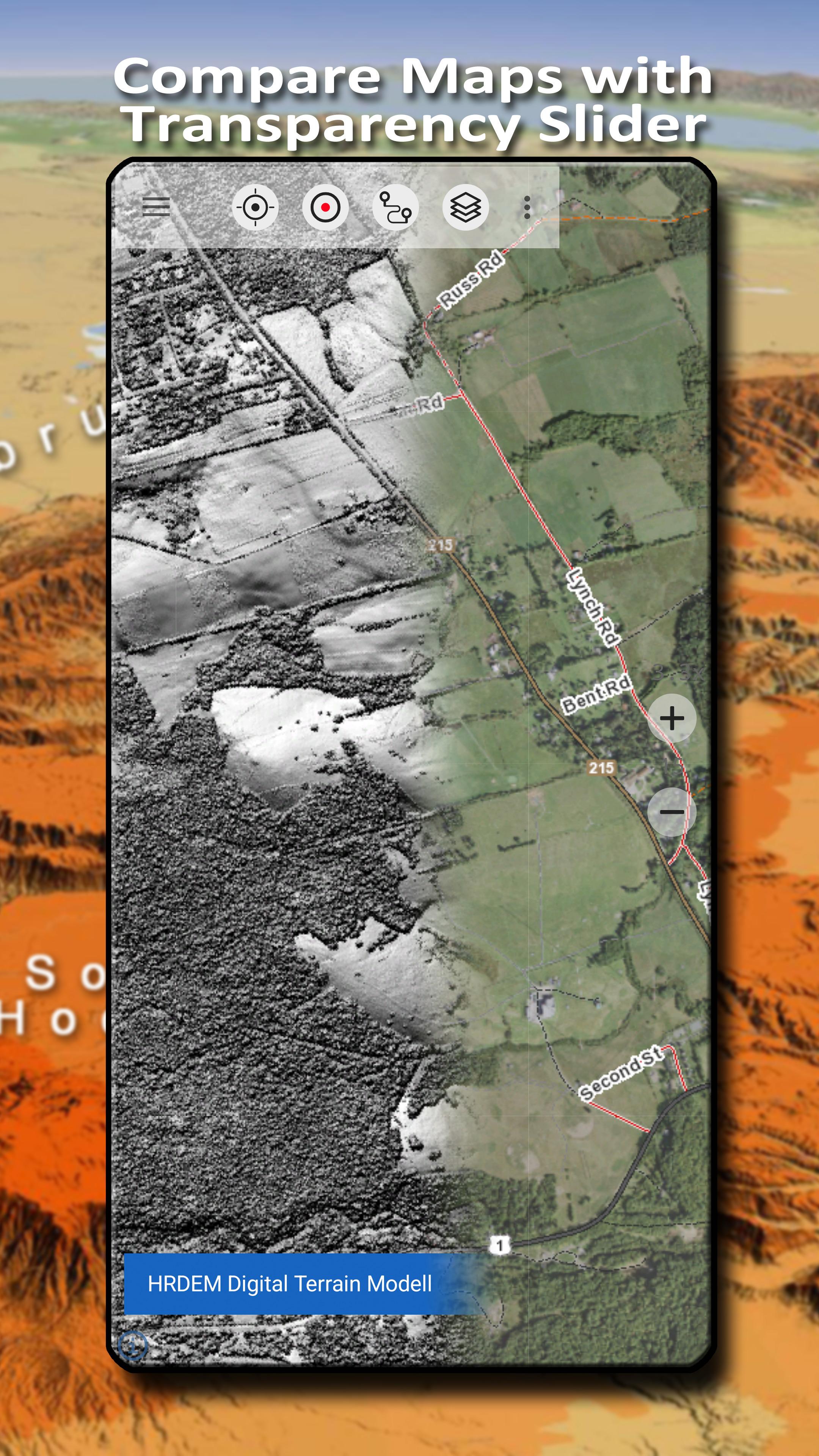
Configure a basemap layer as an overlay and utilize a transparency fader to seamlessly compare maps with each other.
Add maps from other sources:
• Import raster maps in GeoPDF, GeoTiff, MBTiles or Ozi (Oziexplorer OZF2 & OZF3)
• Add web mapping services as WMS or WMTS/Tileserver
• Import OpenStreetMaps in Vectorformat, eg complete USA for just some GBs
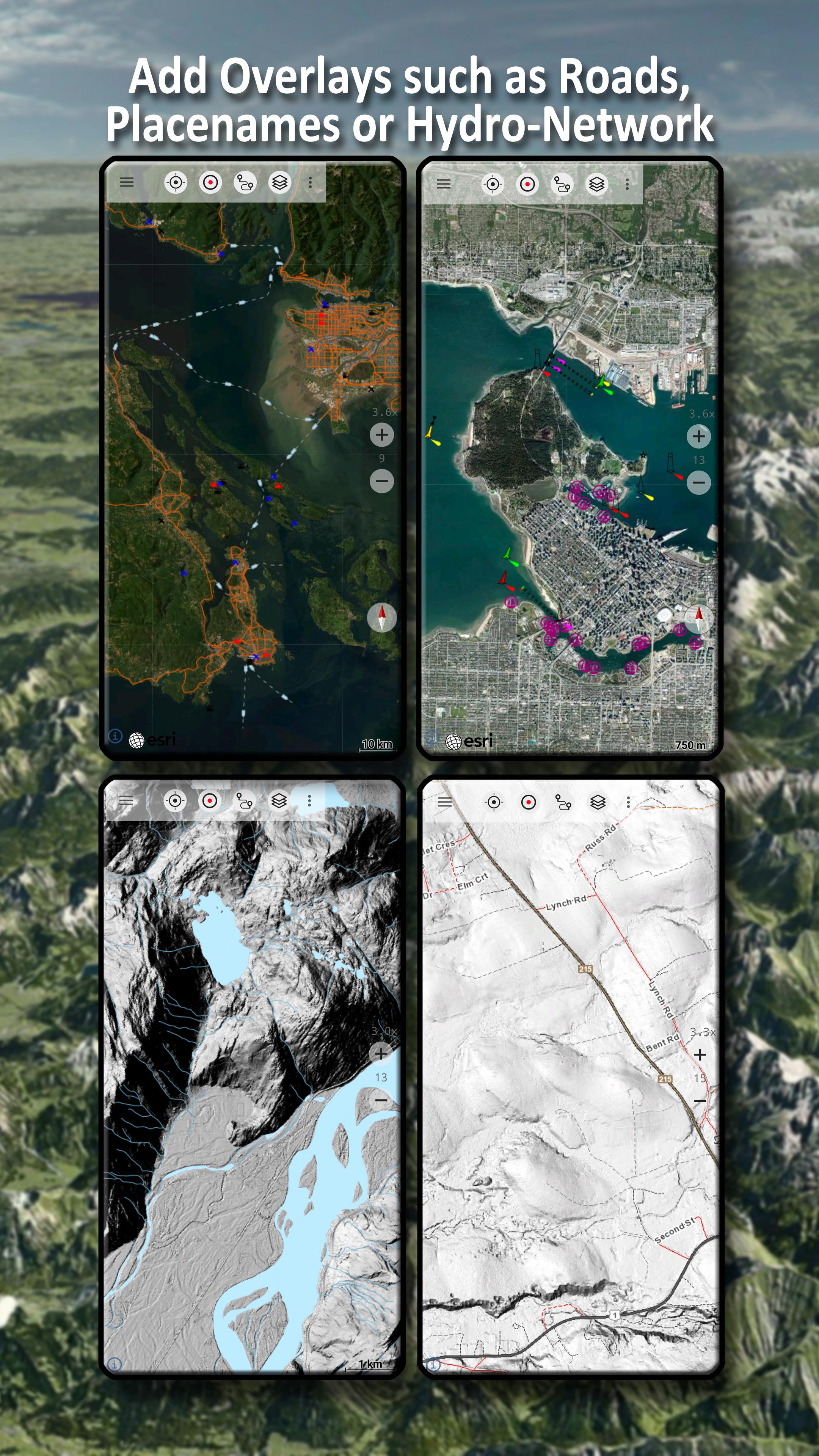
Available Canada map Overlays - add additional information to any other base map:
• CanVec features such as Transportation, Contourlines, Hydronetwork, Toponymic Features, etc.
• Nova Scotia Roads
• Yukon Transportation
Available worldwide overlays:
• Hillshading overlay
• 20m Contourlines
• OpenSeaMap
There is no perfect map. Toggle between the different map layers or use the compare maps feature to find the most interesting route. Especially the old CanMatrix Topos contain many small pathes or other features that are missing on modern maps.
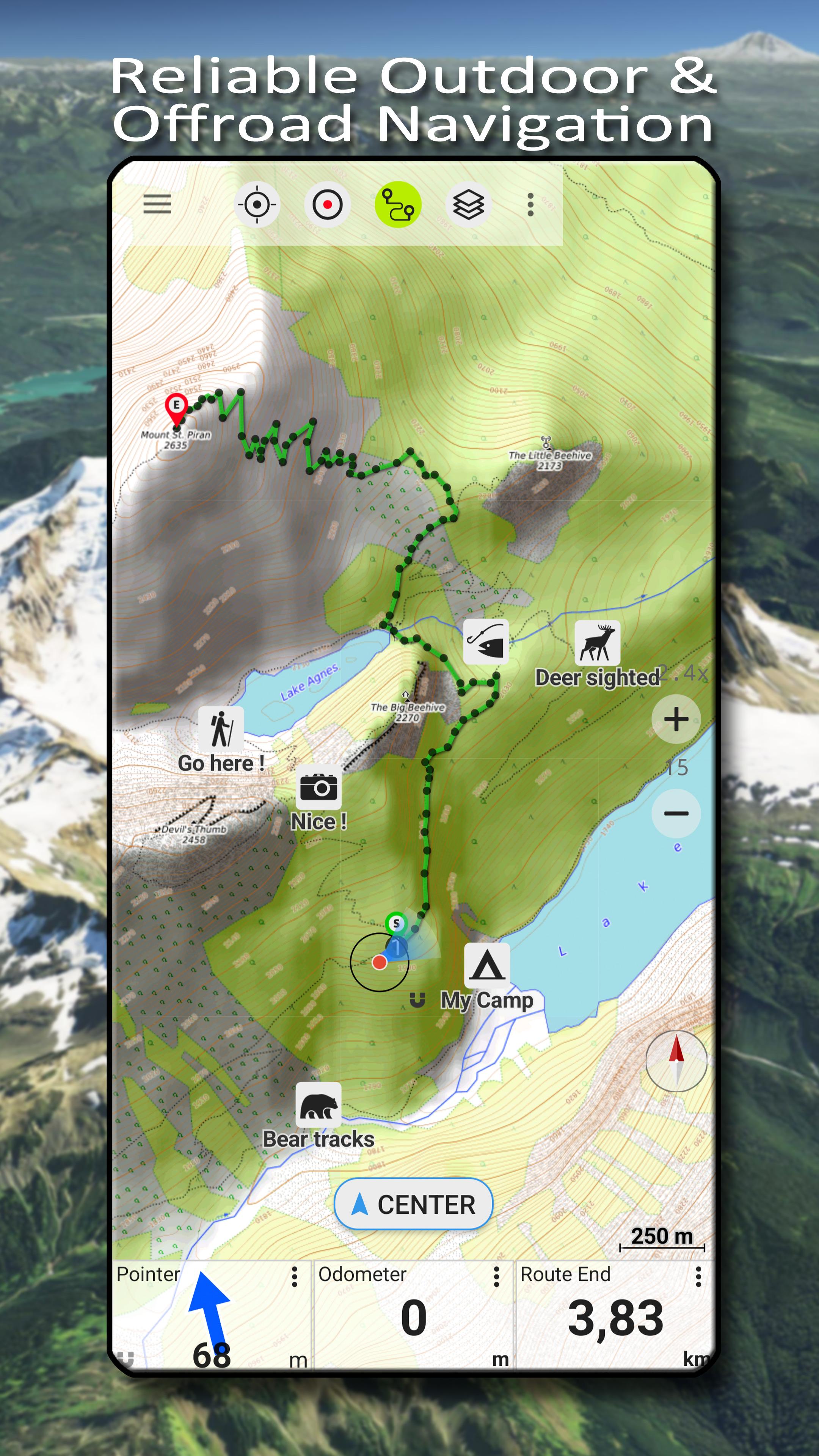
Main features for outdoor-navigation:
• Download map data for OFFLINE USAGE
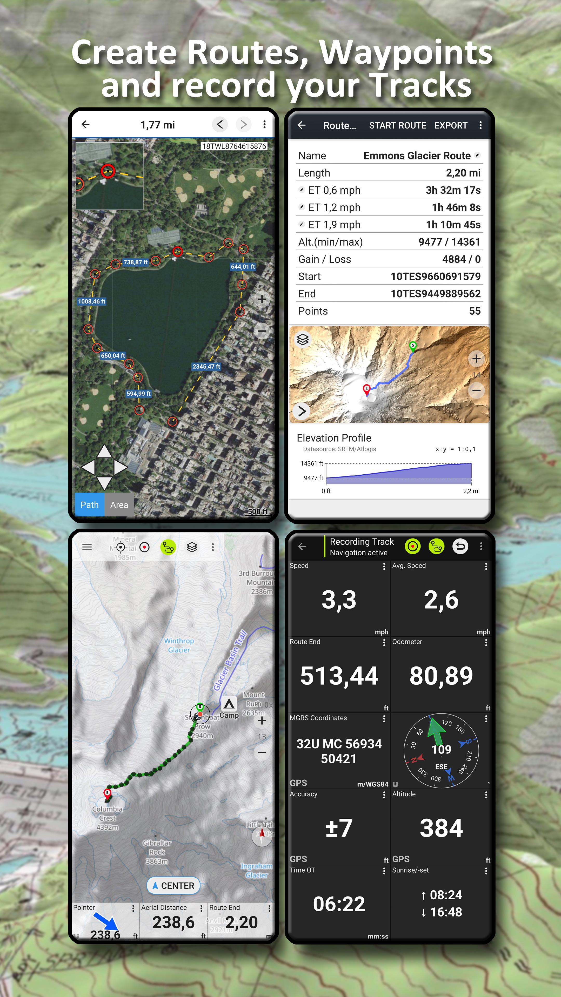
• Measure pathes and aereas
• Create and edit Waypoints
• GoTo-Waypoint-Navigation
• Create and edit Routes
• Route-Navigation (Point-to-Point Navigation)
• Track Recording (with speed, elevation and accuracy profile)
• Tripmaster with fields for odometer, average speed, bearing, elevation, etc.
• GPX/KML/KMZ Import/Export
• Search (placenames, POIs, streets)
• Get elevation and distance
• Customizable datafields in Map View and Tripmaster (e.g. Speed, Distance, Compass, ...)
• Share Waypoints, Tracks or Routes (via eMail, Dropbox, WhatsApp, ..)
• Use coordinates in WGS84, UTM or MGRS/USNG (Military Grid/ US National Grid),
• Track Replay
• and many more ...
Use this navigation app for outdoor activities like hiking, biking, camping, climbing, riding, skiing, canoeing, hunting, snowmobile tours, offroad 4WD tours or search&rescue (SAR).
Add custom waypoints in longitude/latitude, UTM or MGRS/USNG format with WGS84 datum.
Import/Export/Share GPS-Waypoints/Tracks/Routes in GPX or Google Earth KML/KMZ format.
Canadian topographic maps are enhanced with Atlogis® hillshading and placenames.
Credits for topographic map data: "© Department of Natural Resources Canada. All rights reserved."
Please send questions, comments and feature requests to
Canada Topo MapsIntroduction
Canada Topo Maps is a comprehensive and user-friendly mapping application designed to provide detailed topographic information about Canada's vast and diverse landscapes. It offers a wide range of features and tools to cater to the needs of outdoor enthusiasts, hikers, backpackers, hunters, anglers, and anyone interested in exploring the Canadian wilderness.
Features and Functionality
* Interactive Maps: Canada Topo Maps features highly detailed topographic maps that cover the entire country, allowing users to zoom in and out seamlessly and explore different regions. The maps display a wealth of information, including elevation contours, rivers, lakes, trails, roads, and various natural and man-made landmarks.
* GPS Integration: The app seamlessly integrates with GPS devices, enabling users to track their location, record their paths, and navigate through the wilderness with ease. This feature is particularly useful for hikers and backpackers who want to stay on track and explore remote areas safely.
* Route Planning and Navigation: Canada Topo Maps provides robust route planning tools that allow users to create and customize their own trails. They can mark waypoints, measure distances, and calculate elevation profiles to plan their journeys effectively. The app also offers turn-by-turn navigation, ensuring that users stay on the right path.
* Terrain Analysis: The app includes advanced terrain analysis tools that provide detailed information about the topography of the surrounding area. Users can view elevation profiles, slope angles, and aspect to assess the difficulty of trails and make informed decisions about their route.
* Offline Maps: Canada Topo Maps allows users to download and store maps for offline use, eliminating the need for an internet connection while exploring remote areas. This feature ensures that users can access critical mapping information even in areas with limited or no cellular coverage.
* Customizable Layers: The app offers a wide range of customizable layers that can be overlaid on the maps to enhance the user experience. These layers include satellite imagery, aerial photography, historical maps, and various thematic layers such as land use, geology, and hydrology.
* Sharing and Collaboration: Canada Topo Maps enables users to share their maps, routes, and waypoints with others. They can collaborate with friends, family, or fellow outdoor enthusiasts to plan trips, share experiences, and discover new areas together.
Benefits
* Comprehensive and accurate topographic maps for the entire country
* GPS integration for precise location tracking and navigation
* Robust route planning tools for efficient journey planning
* Advanced terrain analysis features for informed decision-making
* Offline maps for reliable access in remote areas
* Customizable layers for enhanced map visualization
* Sharing and collaboration capabilities for seamless trip planning
Conclusion
Canada Topo Maps is an indispensable tool for anyone exploring the diverse landscapes of Canada. Its detailed maps, GPS integration, route planning features, and terrain analysis capabilities provide a comprehensive and user-friendly platform for outdoor enthusiasts. Whether you're a seasoned hiker, a novice backpacker, or simply curious about the Canadian wilderness, Canada Topo Maps will empower you to navigate safely, plan effectively, and discover the hidden gems of this vast and beautiful country.
Offroad & Outdoor Navigation. Multiple Maps: Topo, Aerials, Nautical Charts, etc
Easy to use outdoor navigation app with free access to the best available maps and aerial imagery for Canada.
Choose between 30+ map layers (topos, aerials, sea charts, ...) to plan the perfect trip and
turn your Andoid Phone/Tablet into an outdoor GPS for offline trips into the backcountry.
*** Note: Please use Canada Base Map, Toporama or OpenStreetMap layer if you need most recent topo maps ! ***
Add easily maps from other sources (GeoPDF, GeoTiff, Online Map Services like WMS, ...)
Available base map layers for Canada:
• Topomaps Canada (CanMatrix, seamless coverage at scales 1:50.000 and 1:250.000), incl. USA 1:24.000 - 1:250.000), > 30.000 maps
• Canada Basemap CBMT (CanVec, NTDB, Atlas of Canada)
• Toporama Maps Canada in EN&FR (CanVec, NTDB, Atlas of Canada)
• CanTopo (new Canada Topos at 1:50.000, partial coverage of Canada, mainly in the North)
• Ontario LIO Topo Maps
• Québec Topo Maps 1:20.000
• Saskatchewan Orthophotos
• Nova Scotia Othophotos
• British Columbia Topo Maps
• Nautical Charts ENC
• Digital Elevation Model
• HRDEM (HiRes Elevation Model, parts of Canada)
Worldwide basemap layers:
• OpenStreetMaps (5 different map layouts), also downloadable in space saving vectorformat
• Google Maps (Satellite images, Road- and Terrain-Map)
• Bing Maps (Satellite images, Road-Map)
• ESRI Maps (Satellite images, Road- and Terrain-Map)
• Waze Roads
• Earth At Night
Configure a basemap layer as an overlay and utilize a transparency fader to seamlessly compare maps with each other.
Add maps from other sources:
• Import raster maps in GeoPDF, GeoTiff, MBTiles or Ozi (Oziexplorer OZF2 & OZF3)
• Add web mapping services as WMS or WMTS/Tileserver
• Import OpenStreetMaps in Vectorformat, eg complete USA for just some GBs
Available Canada map Overlays - add additional information to any other base map:
• CanVec features such as Transportation, Contourlines, Hydronetwork, Toponymic Features, etc.
• Nova Scotia Roads
• Yukon Transportation
Available worldwide overlays:
• Hillshading overlay
• 20m Contourlines
• OpenSeaMap
There is no perfect map. Toggle between the different map layers or use the compare maps feature to find the most interesting route. Especially the old CanMatrix Topos contain many small pathes or other features that are missing on modern maps.
Main features for outdoor-navigation:
• Download map data for OFFLINE USAGE
• Measure pathes and aereas
• Create and edit Waypoints
• GoTo-Waypoint-Navigation
• Create and edit Routes
• Route-Navigation (Point-to-Point Navigation)
• Track Recording (with speed, elevation and accuracy profile)
• Tripmaster with fields for odometer, average speed, bearing, elevation, etc.
• GPX/KML/KMZ Import/Export
• Search (placenames, POIs, streets)
• Get elevation and distance
• Customizable datafields in Map View and Tripmaster (e.g. Speed, Distance, Compass, ...)
• Share Waypoints, Tracks or Routes (via eMail, Dropbox, WhatsApp, ..)
• Use coordinates in WGS84, UTM or MGRS/USNG (Military Grid/ US National Grid),
• Track Replay
• and many more ...
Use this navigation app for outdoor activities like hiking, biking, camping, climbing, riding, skiing, canoeing, hunting, snowmobile tours, offroad 4WD tours or search&rescue (SAR).
Add custom waypoints in longitude/latitude, UTM or MGRS/USNG format with WGS84 datum.
Import/Export/Share GPS-Waypoints/Tracks/Routes in GPX or Google Earth KML/KMZ format.
Canadian topographic maps are enhanced with Atlogis® hillshading and placenames.
Credits for topographic map data: "© Department of Natural Resources Canada. All rights reserved."
Please send questions, comments and feature requests to
Canada Topo MapsIntroduction
Canada Topo Maps is a comprehensive and user-friendly mapping application designed to provide detailed topographic information about Canada's vast and diverse landscapes. It offers a wide range of features and tools to cater to the needs of outdoor enthusiasts, hikers, backpackers, hunters, anglers, and anyone interested in exploring the Canadian wilderness.
Features and Functionality
* Interactive Maps: Canada Topo Maps features highly detailed topographic maps that cover the entire country, allowing users to zoom in and out seamlessly and explore different regions. The maps display a wealth of information, including elevation contours, rivers, lakes, trails, roads, and various natural and man-made landmarks.
* GPS Integration: The app seamlessly integrates with GPS devices, enabling users to track their location, record their paths, and navigate through the wilderness with ease. This feature is particularly useful for hikers and backpackers who want to stay on track and explore remote areas safely.
* Route Planning and Navigation: Canada Topo Maps provides robust route planning tools that allow users to create and customize their own trails. They can mark waypoints, measure distances, and calculate elevation profiles to plan their journeys effectively. The app also offers turn-by-turn navigation, ensuring that users stay on the right path.
* Terrain Analysis: The app includes advanced terrain analysis tools that provide detailed information about the topography of the surrounding area. Users can view elevation profiles, slope angles, and aspect to assess the difficulty of trails and make informed decisions about their route.
* Offline Maps: Canada Topo Maps allows users to download and store maps for offline use, eliminating the need for an internet connection while exploring remote areas. This feature ensures that users can access critical mapping information even in areas with limited or no cellular coverage.
* Customizable Layers: The app offers a wide range of customizable layers that can be overlaid on the maps to enhance the user experience. These layers include satellite imagery, aerial photography, historical maps, and various thematic layers such as land use, geology, and hydrology.
* Sharing and Collaboration: Canada Topo Maps enables users to share their maps, routes, and waypoints with others. They can collaborate with friends, family, or fellow outdoor enthusiasts to plan trips, share experiences, and discover new areas together.
Benefits
* Comprehensive and accurate topographic maps for the entire country
* GPS integration for precise location tracking and navigation
* Robust route planning tools for efficient journey planning
* Advanced terrain analysis features for informed decision-making
* Offline maps for reliable access in remote areas
* Customizable layers for enhanced map visualization
* Sharing and collaboration capabilities for seamless trip planning
Conclusion
Canada Topo Maps is an indispensable tool for anyone exploring the diverse landscapes of Canada. Its detailed maps, GPS integration, route planning features, and terrain analysis capabilities provide a comprehensive and user-friendly platform for outdoor enthusiasts. Whether you're a seasoned hiker, a novice backpacker, or simply curious about the Canadian wilderness, Canada Topo Maps will empower you to navigate safely, plan effectively, and discover the hidden gems of this vast and beautiful country.


