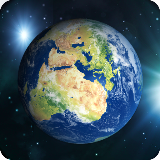

Earth map satellite came with live street view having in built advanced features of living earth map of the world. Live map satellite and satellite world map provide realistic visual maps by using live earth map hd with live earth cam and street view map of the live earth view real time. Live earth map hd has inbuilt features of live earth cam and GPS map of live satellite view where user can search and explore map of the world. Earth map satellite will navigate the world tour for you without moving anywhere by providing you live earth map hd and live map satellite with GPS satellite view and map of the world. GPS map of live earth map hd is capable to show you live satellite world map in realistic visual maps with satellite world map. Here we have live earth cam of the living earth map of the world with different categories throughout the whole world which make you feel like you are travelling while staying at your home because of Earth map satellite that is full of live earth cam with realistic visual maps. Live satellite view is a great sort of entertainment. if you tired of your work and want some relaxation then we have best solution in the form of Earth map satellite. Live map satellite gives a smart way to explore the world map by using living earth map.
Why should you Install Earth Map Satellite?
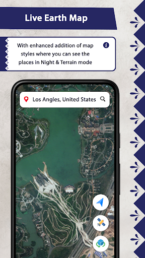
• Earth Map: Live earth map hd shows types of map views like Night, Terrain, Default & Traffic view.
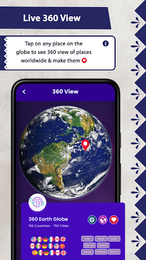
• Advance Earth Cam: Live earth cam hd is a way to see the world without travelling anywhere. Which are categorized in different types where you can mark your favorite live earth cam and can share as well.
• Advance Navigation: Navigator is a driving directions app which facilitates you an easy and advance way of navigation where you can navigate by using valued features of GPS navigation which are navigation by contacts, by entering zip code & by entering Latitude and Longitude in the address bar.
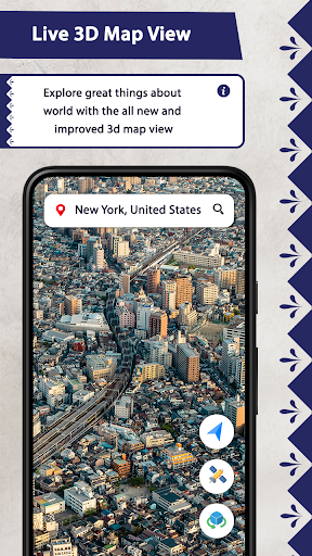
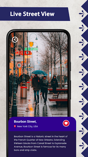
• Street View: An easy access towards live Street View of the earth map which are latest and smoothly reachable in earth map satellite.
•GPS Cam: Make your moments memorable by using GPS Cam which catches your moments in details wherever you are, it will tell your current location & Time as well. You can save, edit & share your pictures with latitude & longitude of that location.
• Speedometer: All in one speedometer includes Analog & Digital with HUD and detailed information.
Earth map satellite is not only about explore the world without flight, rather have advance features of navigation and driving directions which allow users to navigate in any way he wants, users have options to navigate by using directions app. Earth map satellite came with advance features of GPS navigation where you have a choice to navigate in either way you want to navigate by using Contact of the person whom you want to visit or by entering zip code of the area where you want to go. Moreover you have a 3rd option as well that you have to enter latitude and longitude in the address bar and navigator will take you towards your destination.
Earth map satellite is more than earth cam and satellite map which shows living earth map with live satellite view and live street view. Live earth cam and GPS satellite entertain you with live webcam of the live satellite view with realistic visual maps. Live earth cam and live webcam of GPS satellite view provides earth live webcam on the live map. If you have any query or suggestion please write us at [email protected]
Earth Map Satellite is an immersive and informative application that allows users to explore the globe from the comfort of their own devices. With high-resolution satellite imagery, real-time weather updates, and a wealth of geographical data, this app provides a comprehensive and interactive experience for anyone interested in our planet.
Intuitive Navigation and Exploration
Earth Map Satellite features an intuitive interface that makes it easy to navigate and explore different regions of the world. Users can zoom in and out to view detailed satellite imagery, pan across the globe, and search for specific locations. The app also offers various map modes, including terrain, satellite, hybrid, and street view, allowing users to customize their viewing experience based on their preferences.
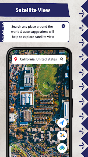
High-Resolution Satellite Imagery
The app boasts high-resolution satellite imagery that provides a stunningly detailed view of the Earth's surface. Users can explore natural wonders, urban landscapes, and even individual buildings with incredible clarity. The imagery is regularly updated, ensuring that users have access to the most recent and accurate satellite data.
Real-Time Weather Updates
Earth Map Satellite seamlessly integrates real-time weather data to provide users with up-to-date information on current weather conditions around the world. The app displays weather overlays that indicate temperature, precipitation, cloud cover, and wind patterns. This feature allows users to track weather systems, plan outdoor activities, and stay informed about weather-related events.
Comprehensive Geographical Data
In addition to satellite imagery and weather data, Earth Map Satellite offers a vast collection of geographical information. Users can access data on countries, cities, mountains, rivers, and other geographical features. The app also includes historical maps, population statistics, and economic data, providing users with a comprehensive understanding of the world's geography.
Educational and Informative
Earth Map Satellite is not only a visually stunning app but also a valuable educational tool. It provides students, researchers, and anyone interested in geography with a wealth of information and resources. The app can be used to explore different cultures, study environmental issues, and gain a deeper understanding of the planet we inhabit.
Immersive and Engaging Experience
Earth Map Satellite offers an immersive and engaging experience that allows users to feel like they are exploring the world firsthand. The high-resolution imagery, real-time weather updates, and comprehensive geographical data combine to create a virtual globe that users can interact with and learn from. The app is perfect for anyone who wants to satisfy their curiosity about the planet, explore new places, or simply enjoy the beauty of our Earth from a unique perspective.
Earth map satellite came with live street view having in built advanced features of living earth map of the world. Live map satellite and satellite world map provide realistic visual maps by using live earth map hd with live earth cam and street view map of the live earth view real time. Live earth map hd has inbuilt features of live earth cam and GPS map of live satellite view where user can search and explore map of the world. Earth map satellite will navigate the world tour for you without moving anywhere by providing you live earth map hd and live map satellite with GPS satellite view and map of the world. GPS map of live earth map hd is capable to show you live satellite world map in realistic visual maps with satellite world map. Here we have live earth cam of the living earth map of the world with different categories throughout the whole world which make you feel like you are travelling while staying at your home because of Earth map satellite that is full of live earth cam with realistic visual maps. Live satellite view is a great sort of entertainment. if you tired of your work and want some relaxation then we have best solution in the form of Earth map satellite. Live map satellite gives a smart way to explore the world map by using living earth map.
Why should you Install Earth Map Satellite?
• Earth Map: Live earth map hd shows types of map views like Night, Terrain, Default & Traffic view.
• Advance Earth Cam: Live earth cam hd is a way to see the world without travelling anywhere. Which are categorized in different types where you can mark your favorite live earth cam and can share as well.
• Advance Navigation: Navigator is a driving directions app which facilitates you an easy and advance way of navigation where you can navigate by using valued features of GPS navigation which are navigation by contacts, by entering zip code & by entering Latitude and Longitude in the address bar.
• Street View: An easy access towards live Street View of the earth map which are latest and smoothly reachable in earth map satellite.
•GPS Cam: Make your moments memorable by using GPS Cam which catches your moments in details wherever you are, it will tell your current location & Time as well. You can save, edit & share your pictures with latitude & longitude of that location.
• Speedometer: All in one speedometer includes Analog & Digital with HUD and detailed information.
Earth map satellite is not only about explore the world without flight, rather have advance features of navigation and driving directions which allow users to navigate in any way he wants, users have options to navigate by using directions app. Earth map satellite came with advance features of GPS navigation where you have a choice to navigate in either way you want to navigate by using Contact of the person whom you want to visit or by entering zip code of the area where you want to go. Moreover you have a 3rd option as well that you have to enter latitude and longitude in the address bar and navigator will take you towards your destination.
Earth map satellite is more than earth cam and satellite map which shows living earth map with live satellite view and live street view. Live earth cam and GPS satellite entertain you with live webcam of the live satellite view with realistic visual maps. Live earth cam and live webcam of GPS satellite view provides earth live webcam on the live map. If you have any query or suggestion please write us at [email protected]
Earth Map Satellite is an immersive and informative application that allows users to explore the globe from the comfort of their own devices. With high-resolution satellite imagery, real-time weather updates, and a wealth of geographical data, this app provides a comprehensive and interactive experience for anyone interested in our planet.
Intuitive Navigation and Exploration
Earth Map Satellite features an intuitive interface that makes it easy to navigate and explore different regions of the world. Users can zoom in and out to view detailed satellite imagery, pan across the globe, and search for specific locations. The app also offers various map modes, including terrain, satellite, hybrid, and street view, allowing users to customize their viewing experience based on their preferences.
High-Resolution Satellite Imagery
The app boasts high-resolution satellite imagery that provides a stunningly detailed view of the Earth's surface. Users can explore natural wonders, urban landscapes, and even individual buildings with incredible clarity. The imagery is regularly updated, ensuring that users have access to the most recent and accurate satellite data.
Real-Time Weather Updates
Earth Map Satellite seamlessly integrates real-time weather data to provide users with up-to-date information on current weather conditions around the world. The app displays weather overlays that indicate temperature, precipitation, cloud cover, and wind patterns. This feature allows users to track weather systems, plan outdoor activities, and stay informed about weather-related events.
Comprehensive Geographical Data
In addition to satellite imagery and weather data, Earth Map Satellite offers a vast collection of geographical information. Users can access data on countries, cities, mountains, rivers, and other geographical features. The app also includes historical maps, population statistics, and economic data, providing users with a comprehensive understanding of the world's geography.
Educational and Informative
Earth Map Satellite is not only a visually stunning app but also a valuable educational tool. It provides students, researchers, and anyone interested in geography with a wealth of information and resources. The app can be used to explore different cultures, study environmental issues, and gain a deeper understanding of the planet we inhabit.
Immersive and Engaging Experience
Earth Map Satellite offers an immersive and engaging experience that allows users to feel like they are exploring the world firsthand. The high-resolution imagery, real-time weather updates, and comprehensive geographical data combine to create a virtual globe that users can interact with and learn from. The app is perfect for anyone who wants to satisfy their curiosity about the planet, explore new places, or simply enjoy the beauty of our Earth from a unique perspective.


