

When you take a photo, this app will add the map, location, weather to picture.
Track your live location along with your captured photos by GPS Map Camera: Geotag Photos & Add GPS Location Application. Send your geotagged location of Street / Place added photos to your Family & Friends, and let them know about your best Earth travel memories.
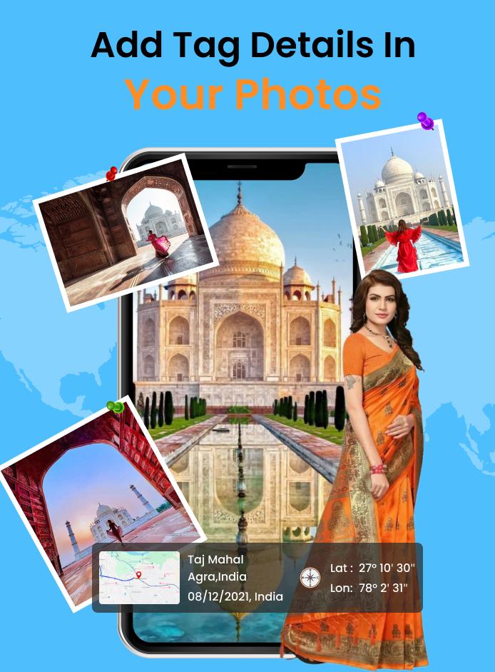
When you take a picture, this application will paste the map, address, weather and date to picture. (GPS latitude/longitude information also could be included)
This application is easy to get/set GPS location and GPS coordination for GPS Tag request.
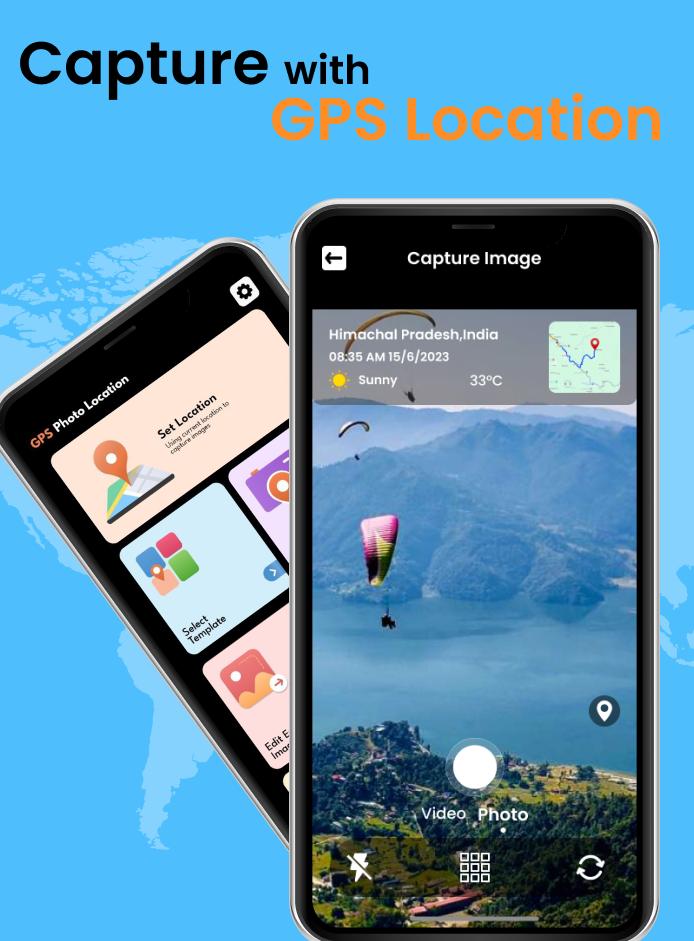
Using live GPS Camera add GPS Location address details with current weather information, date, time, longitude & latitude while you click your photos.
Also add GPS location details, weather, date & time on your photos from gallery.
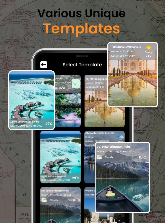
🌟 Custom elements in timestamp template (Real-time preview of adjustments):
◆ Show location: present real-time location address when shooting;
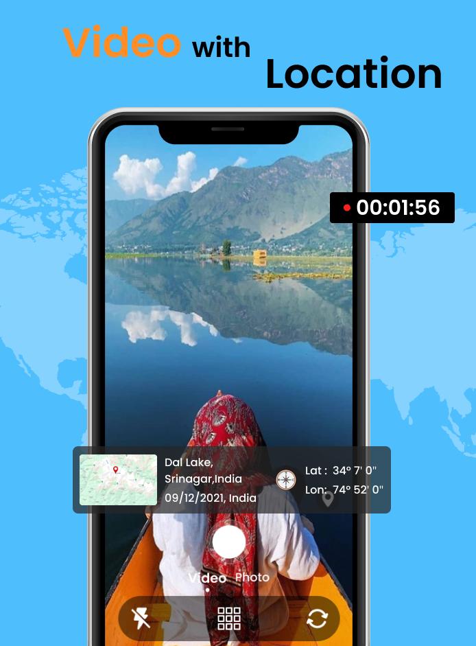
◆ Show time & date: you can add time & date when you take this picture or video;
◆ Show map: put map location on photos or videos;
◆ Show latitude & longitude: have GPS coordinates shown on camera;
◆ Show altitude: add the surface elevation of your real-time location;
◆ Add custom text & emoji on photos or videos: e.g. you can leave a note like "The package is at your front door."
◆ DIY your own timestamp style:
- All kinds of font colors
- All kinds of colors and 0%-100% opacity of timestamp background
- Align contents: left align, center align, right align
- Change positions of timestamp: top left, top right, center, bottom left, bottom right
🌟 Advanced settings in camera:
◆ Autofocus
◆ Zoom in & Zoom out
◆ Capture the picture while recording the video
◆ Auto-rotate the camera in portrait or landscape mode
◆ Shooting quality: low, standard, high
◆ Assistive grid to compose your pictures/videos
◆ Mirror camera
◆ Aspect ratio: 1:1 or 4:3 or 16:9
◆ Remote control timer(2s/5s/10s) with countdown numbers display on the screen
◆ Flash
◆ Photo library
Note: View nearby places as camera direction functionality will only available if your device have orientation sensor / magnetic sensor, else it will display list of nearby places.
#permission:
-location access: to get current location of user
-storage access: to get photos of device,to store created photos in storage
-camera access: to open camera
GPS Map Camera: Stamp CameraGPS Map Camera is a versatile mobile application that seamlessly integrates GPS tracking, photo stamping, and navigation features. It empowers users to capture and organize their travel experiences with ease and precision.
Key Features:
* GPS Tracking: GPS Map Camera automatically logs your location while taking photos. This allows you to pinpoint the exact spot where each image was captured.
* Photo Stamping: Add custom stamps to your photos, including date, time, location, and other relevant information. This feature helps you keep track of important details and create a visual timeline of your travels.
* Navigation: GPS Map Camera seamlessly integrates with navigation apps, allowing you to plan and navigate your routes directly from the app. It provides turn-by-turn directions and real-time traffic updates.
* Photo Organization: The app automatically organizes your photos based on location, making it easy to find and access images from specific places.
* Share and Export: Easily share your photos with friends and family via social media, email, or messaging apps. You can also export photos in various formats, including JPG, PNG, and PDF.
Benefits:
* Enhanced Travel Memories: GPS Map Camera helps you create a rich and detailed record of your travels. By capturing location data and adding custom stamps, you can relive your experiences and share them with others in a more immersive way.
* Improved Navigation: With GPS Map Camera, you can effortlessly navigate to points of interest and find your way around unfamiliar locations. The integration with navigation apps provides real-time directions and traffic updates, ensuring a smooth and stress-free journey.
* Organized Photo Library: The app's automatic photo organization feature eliminates the hassle of manually sorting and categorizing your travel photos. You can quickly access images from specific locations and create memorable photo albums.
* Shareable Travel Experiences: GPS Map Camera makes it easy to share your travel experiences with others. You can quickly share photos with custom stamps, allowing your friends and family to experience your adventures from their own homes.
Conclusion:
GPS Map Camera is an indispensable tool for travelers, photographers, and anyone who wants to enhance their travel experiences. Its intuitive features and seamless integration with GPS tracking and navigation make it the perfect companion for capturing and organizing your travel memories.
When you take a photo, this app will add the map, location, weather to picture.
Track your live location along with your captured photos by GPS Map Camera: Geotag Photos & Add GPS Location Application. Send your geotagged location of Street / Place added photos to your Family & Friends, and let them know about your best Earth travel memories.
When you take a picture, this application will paste the map, address, weather and date to picture. (GPS latitude/longitude information also could be included)
This application is easy to get/set GPS location and GPS coordination for GPS Tag request.
Using live GPS Camera add GPS Location address details with current weather information, date, time, longitude & latitude while you click your photos.
Also add GPS location details, weather, date & time on your photos from gallery.
🌟 Custom elements in timestamp template (Real-time preview of adjustments):
◆ Show location: present real-time location address when shooting;
◆ Show time & date: you can add time & date when you take this picture or video;
◆ Show map: put map location on photos or videos;
◆ Show latitude & longitude: have GPS coordinates shown on camera;
◆ Show altitude: add the surface elevation of your real-time location;
◆ Add custom text & emoji on photos or videos: e.g. you can leave a note like "The package is at your front door."
◆ DIY your own timestamp style:
- All kinds of font colors
- All kinds of colors and 0%-100% opacity of timestamp background
- Align contents: left align, center align, right align
- Change positions of timestamp: top left, top right, center, bottom left, bottom right
🌟 Advanced settings in camera:
◆ Autofocus
◆ Zoom in & Zoom out
◆ Capture the picture while recording the video
◆ Auto-rotate the camera in portrait or landscape mode
◆ Shooting quality: low, standard, high
◆ Assistive grid to compose your pictures/videos
◆ Mirror camera
◆ Aspect ratio: 1:1 or 4:3 or 16:9
◆ Remote control timer(2s/5s/10s) with countdown numbers display on the screen
◆ Flash
◆ Photo library
Note: View nearby places as camera direction functionality will only available if your device have orientation sensor / magnetic sensor, else it will display list of nearby places.
#permission:
-location access: to get current location of user
-storage access: to get photos of device,to store created photos in storage
-camera access: to open camera
GPS Map Camera: Stamp CameraGPS Map Camera is a versatile mobile application that seamlessly integrates GPS tracking, photo stamping, and navigation features. It empowers users to capture and organize their travel experiences with ease and precision.
Key Features:
* GPS Tracking: GPS Map Camera automatically logs your location while taking photos. This allows you to pinpoint the exact spot where each image was captured.
* Photo Stamping: Add custom stamps to your photos, including date, time, location, and other relevant information. This feature helps you keep track of important details and create a visual timeline of your travels.
* Navigation: GPS Map Camera seamlessly integrates with navigation apps, allowing you to plan and navigate your routes directly from the app. It provides turn-by-turn directions and real-time traffic updates.
* Photo Organization: The app automatically organizes your photos based on location, making it easy to find and access images from specific places.
* Share and Export: Easily share your photos with friends and family via social media, email, or messaging apps. You can also export photos in various formats, including JPG, PNG, and PDF.
Benefits:
* Enhanced Travel Memories: GPS Map Camera helps you create a rich and detailed record of your travels. By capturing location data and adding custom stamps, you can relive your experiences and share them with others in a more immersive way.
* Improved Navigation: With GPS Map Camera, you can effortlessly navigate to points of interest and find your way around unfamiliar locations. The integration with navigation apps provides real-time directions and traffic updates, ensuring a smooth and stress-free journey.
* Organized Photo Library: The app's automatic photo organization feature eliminates the hassle of manually sorting and categorizing your travel photos. You can quickly access images from specific locations and create memorable photo albums.
* Shareable Travel Experiences: GPS Map Camera makes it easy to share your travel experiences with others. You can quickly share photos with custom stamps, allowing your friends and family to experience your adventures from their own homes.
Conclusion:
GPS Map Camera is an indispensable tool for travelers, photographers, and anyone who wants to enhance their travel experiences. Its intuitive features and seamless integration with GPS tracking and navigation make it the perfect companion for capturing and organizing your travel memories.


