

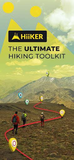

HiiKER is the ultimate hiking app that is dedicated to building tools specifically for the hiking community.
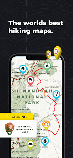
Download thousands of Hiking trail maps for FREE
With HiiKER, you can download over 65,000 of the world’s best hiking, tramping, walking and backpacking trails right to your smartphone for free. Looking for the perfect Family hike? Or want to take the dog out on a walk in nature? You’ll find the trail that’s right for you with our powerful search tool. And navigate it completely offline, for free.
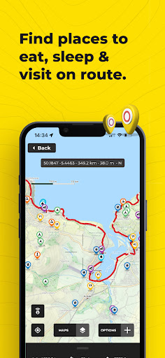
Plan Ahead
You’ll find thousands of accommodation and amenity options for your adventures. Plan ahead with the perfect lunch spot, campsite, resupply town or maybe even a 5-star hotel on your hiking trip.
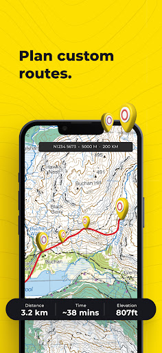
Create your own custom route
The HiiKER Route Planner will enable you to blaze your own trail and plan a custom route. View this in your saved trails to navigate with your outdoor adventure buddies. Better yet, download it to your device for free.
Offline Maps
With HiiKER you can download all your favourite trails to your phone to use offline FOR FREE - even in airplane mode. This is perfect for those adventures where cell service is not guaranteed. It is also much less intensive on your battery life, meaning you can use it for longer!
Import GPX files
Got a GPX file from a friend or another app like alltrails, outdooractive, strava, komoot? Import it to HiiKER and make your own edits to the route before hitting the trail.
Track your Hikes
The HiiKER Tracker records your hiking activity and gives you in-depth detail about your adventures that you can share with your adventure crew. Maybe you can set that unsupported FKT?
High-Resolution Map layers
We are building the most comprehensive selection of FREE map layers available. You'll find the layer that is best suited to your hike. These include
Open street maps
Satellite
Nature
Mobile Atlas
Landscape
Pioneer
Transport
GPX Download
Export GPX files of one of the thousands of hiking trails on HiiKER for FREE. Sync them with your other gps devices, such as Garmin, suunto, coros etc.
HiiKER PRO+ pricing starts from €6.49 per month.
[PRO+] Measure the Distance
Use our handy measurement tool to know what distance, terrain and elevation lie ahead.
[PRO+] Stage by stage breakdown
Planning a longer hike and want to divide the trail into smaller segments? Our stage-by-stage breakdown helps you plan your days better with clever distance and elevation management.
[PRO+] Premium High-Resolution maps
Upgrading to HiiKER PRO+ gets you access to some of the world's best map developers in the world on the platform. These high-resolution maps include
OS Maps (Ordnance Survey)
EastWest Mapping
USGS
IGN
OSi (Ordnance Survey Ireland)
Swiss Topo
All of these maps can be used in conjunction with other HiiKER features.
Quality Data
We don’t just put any trail on HiiKER. We partner with trail organisations, National parks and other trusted sources around the world to bring you the most up-to-date and official trail data available.
These organisations are critical to the enjoyment and safety of hikers. As many are voluntary or NFP organisations, we give users the ability to donate to them for the valuable work they do.
Help and Support
Contact us at [email protected]
Legal
Terms of Service: https://hiiker.app/terms-of-service
Hiiker is a comprehensive hiking maps app that empowers outdoor enthusiasts with detailed trail information, offline maps, and a vibrant community. Its intuitive interface and feature-rich platform make it an indispensable tool for hikers of all levels.
Trail Maps and Navigation
Hiiker boasts a vast database of meticulously curated trail maps, covering countless hiking trails worldwide. Each map provides accurate elevation profiles, trail distances, and estimated hiking times. The app's GPS functionality allows users to track their progress, ensuring they stay on the right path. Offline maps enable navigation even in areas without internet connectivity.
Community Features
Hiiker fosters a thriving community of hikers who share their experiences, trail reviews, and photos. Users can connect with other hikers, discover new trails, and contribute to the app's ever-growing knowledge base. The app's social feed provides a platform for hikers to ask questions, offer advice, and share their adventures.
Trip Planning and Management
Hiiker's trip planning tools help hikers organize their adventures seamlessly. Users can create custom itineraries, add waypoints, and estimate distances and elevation gains. The app's built-in weather forecast provides essential information for planning safe and enjoyable hikes.
Safety and Emergency Features
Hiiker prioritizes safety by offering an SOS function that sends a distress signal with the user's location to emergency contacts. The app also includes a whistle feature that can alert others in case of an emergency. Hikers can share their planned routes with friends and family, providing peace of mind and ensuring their well-being.
Customization and Personalization
Hiiker allows users to customize the app's settings to suit their preferences. They can adjust map styles, choose different units of measurement, and personalize their profile with a unique username and avatar. The app also supports multiple languages, catering to a global audience.
Premium Features
Hiiker offers a premium subscription that unlocks additional features, including advanced map downloads, unlimited offline maps, and ad-free navigation. Premium users also gain access to exclusive content, such as curated trail recommendations and detailed trail descriptions.
Conclusion
Hiiker is an indispensable tool for hikers of all levels, offering a comprehensive suite of features that enhance the hiking experience. Its detailed trail maps, vibrant community, trip planning tools, and safety features empower hikers to explore the outdoors confidently and safely. Whether planning a day hike or an extended backpacking adventure, Hiiker is the ultimate companion for outdoor enthusiasts.
HiiKER is the ultimate hiking app that is dedicated to building tools specifically for the hiking community.
Download thousands of Hiking trail maps for FREE
With HiiKER, you can download over 65,000 of the world’s best hiking, tramping, walking and backpacking trails right to your smartphone for free. Looking for the perfect Family hike? Or want to take the dog out on a walk in nature? You’ll find the trail that’s right for you with our powerful search tool. And navigate it completely offline, for free.
Plan Ahead
You’ll find thousands of accommodation and amenity options for your adventures. Plan ahead with the perfect lunch spot, campsite, resupply town or maybe even a 5-star hotel on your hiking trip.
Create your own custom route
The HiiKER Route Planner will enable you to blaze your own trail and plan a custom route. View this in your saved trails to navigate with your outdoor adventure buddies. Better yet, download it to your device for free.
Offline Maps
With HiiKER you can download all your favourite trails to your phone to use offline FOR FREE - even in airplane mode. This is perfect for those adventures where cell service is not guaranteed. It is also much less intensive on your battery life, meaning you can use it for longer!
Import GPX files
Got a GPX file from a friend or another app like alltrails, outdooractive, strava, komoot? Import it to HiiKER and make your own edits to the route before hitting the trail.
Track your Hikes
The HiiKER Tracker records your hiking activity and gives you in-depth detail about your adventures that you can share with your adventure crew. Maybe you can set that unsupported FKT?
High-Resolution Map layers
We are building the most comprehensive selection of FREE map layers available. You'll find the layer that is best suited to your hike. These include
Open street maps
Satellite
Nature
Mobile Atlas
Landscape
Pioneer
Transport
GPX Download
Export GPX files of one of the thousands of hiking trails on HiiKER for FREE. Sync them with your other gps devices, such as Garmin, suunto, coros etc.
HiiKER PRO+ pricing starts from €6.49 per month.
[PRO+] Measure the Distance
Use our handy measurement tool to know what distance, terrain and elevation lie ahead.
[PRO+] Stage by stage breakdown
Planning a longer hike and want to divide the trail into smaller segments? Our stage-by-stage breakdown helps you plan your days better with clever distance and elevation management.
[PRO+] Premium High-Resolution maps
Upgrading to HiiKER PRO+ gets you access to some of the world's best map developers in the world on the platform. These high-resolution maps include
OS Maps (Ordnance Survey)
EastWest Mapping
USGS
IGN
OSi (Ordnance Survey Ireland)
Swiss Topo
All of these maps can be used in conjunction with other HiiKER features.
Quality Data
We don’t just put any trail on HiiKER. We partner with trail organisations, National parks and other trusted sources around the world to bring you the most up-to-date and official trail data available.
These organisations are critical to the enjoyment and safety of hikers. As many are voluntary or NFP organisations, we give users the ability to donate to them for the valuable work they do.
Help and Support
Contact us at [email protected]
Legal
Terms of Service: https://hiiker.app/terms-of-service
Hiiker is a comprehensive hiking maps app that empowers outdoor enthusiasts with detailed trail information, offline maps, and a vibrant community. Its intuitive interface and feature-rich platform make it an indispensable tool for hikers of all levels.
Trail Maps and Navigation
Hiiker boasts a vast database of meticulously curated trail maps, covering countless hiking trails worldwide. Each map provides accurate elevation profiles, trail distances, and estimated hiking times. The app's GPS functionality allows users to track their progress, ensuring they stay on the right path. Offline maps enable navigation even in areas without internet connectivity.
Community Features
Hiiker fosters a thriving community of hikers who share their experiences, trail reviews, and photos. Users can connect with other hikers, discover new trails, and contribute to the app's ever-growing knowledge base. The app's social feed provides a platform for hikers to ask questions, offer advice, and share their adventures.
Trip Planning and Management
Hiiker's trip planning tools help hikers organize their adventures seamlessly. Users can create custom itineraries, add waypoints, and estimate distances and elevation gains. The app's built-in weather forecast provides essential information for planning safe and enjoyable hikes.
Safety and Emergency Features
Hiiker prioritizes safety by offering an SOS function that sends a distress signal with the user's location to emergency contacts. The app also includes a whistle feature that can alert others in case of an emergency. Hikers can share their planned routes with friends and family, providing peace of mind and ensuring their well-being.
Customization and Personalization
Hiiker allows users to customize the app's settings to suit their preferences. They can adjust map styles, choose different units of measurement, and personalize their profile with a unique username and avatar. The app also supports multiple languages, catering to a global audience.
Premium Features
Hiiker offers a premium subscription that unlocks additional features, including advanced map downloads, unlimited offline maps, and ad-free navigation. Premium users also gain access to exclusive content, such as curated trail recommendations and detailed trail descriptions.
Conclusion
Hiiker is an indispensable tool for hikers of all levels, offering a comprehensive suite of features that enhance the hiking experience. Its detailed trail maps, vibrant community, trip planning tools, and safety features empower hikers to explore the outdoors confidently and safely. Whether planning a day hike or an extended backpacking adventure, Hiiker is the ultimate companion for outdoor enthusiasts.


