
Water levels and flows indicate status and water flow in watercourses Czech Republic and Slovakia
Are you interested in information about the state (level) and flow of watercourses?
Are you still tired of looking for information on the status and flow on the pages of individual river basins?
Does it need to be notified when the level of the selected water flow rises above your set limit?
Are you a paddler and are you interested in the passability of a popular stream?
The application States and flows of watercourses offers information on the status and flows of water in watercourses throughout the Czech and Slovak Republics. For paddlers, it also offers information on the navigability of streams.
Uses information:
1) from the pages of individual river basins:
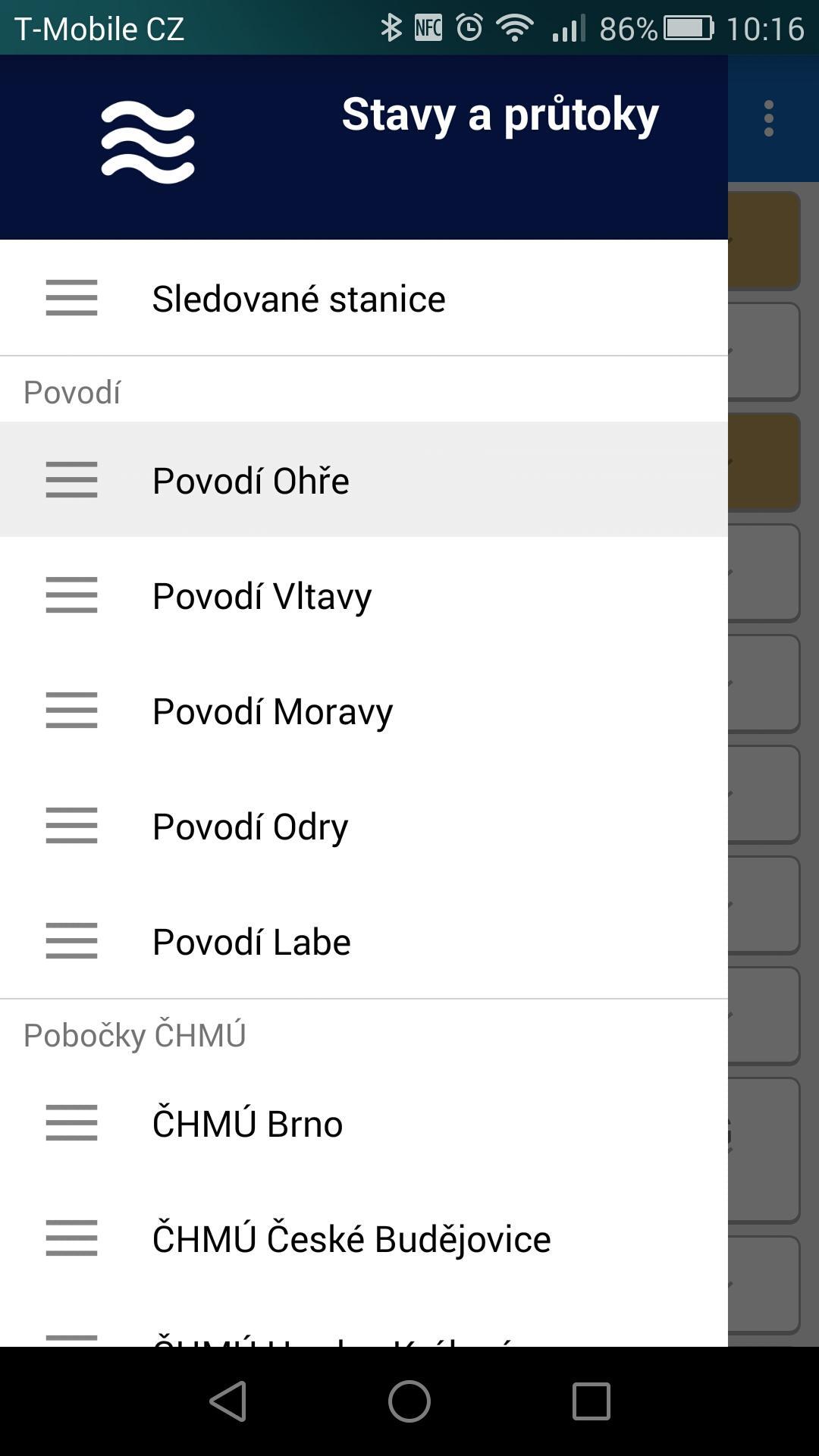
»Ohře River Basin
»Vltava basin
»The Elbe basin
»The Morava River Basin
»The Odra River Basin
2) from the website of the Czech Hydrometeorological Institute - CHMI. In this case, the data are sorted according to CHMI branches:
»CHMI Brno
»CHMI České Budějovice
»CHMI Hradec Králové
»CHMI Ostrava
»CHMI Pilsen
»CHMI Prague
»CHMI Ústí nad Labem
3) from the pages of the flood system of small watercourses:
»DVT SESO (North Bohemian Association of Municipalities)
»DVT Pilsen
»DVT Hranice
»DVT Bystřice
»DVT Easter Eggs
»DVT KRKV (Karlovy Vary Region)
»DVT Tábor
»DVT Lanškroun
»DVT Říčany
4) from the Hladiny.cz website:
»Stations of towns and municipalities (LVS)
5) from the VOX warning systems website:
»VOX - levels
6) from the pages of the SK river basin:
»OZ Bratislava
»OZ Piešťany
»OZ Banská Bystrica
»OZ Košice
7) from the website of the Slovak Hydrometeorological Institute - SHMÚ:
»SHMÚ Bratislava region
»SHMÚ Žilina region
»SHMÚ Banskobystrický region
»SHMÚ Košice region
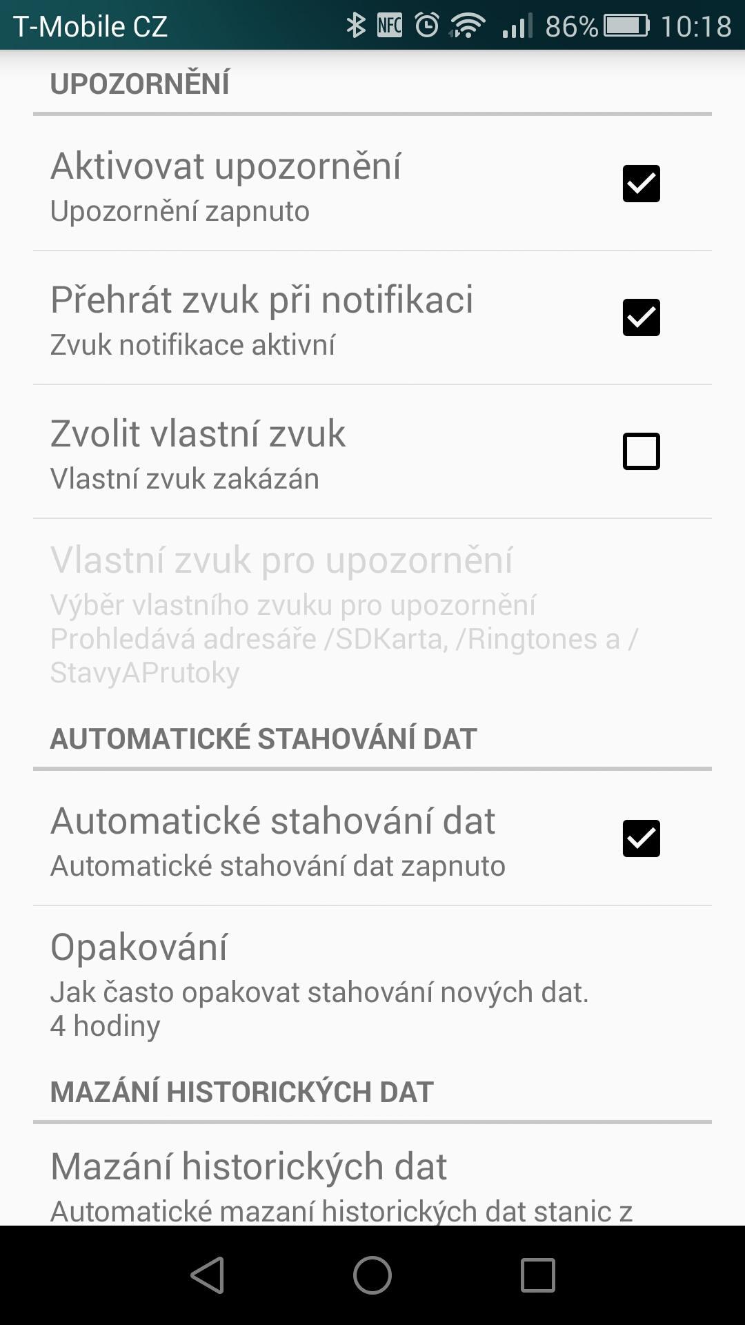
Application functions:
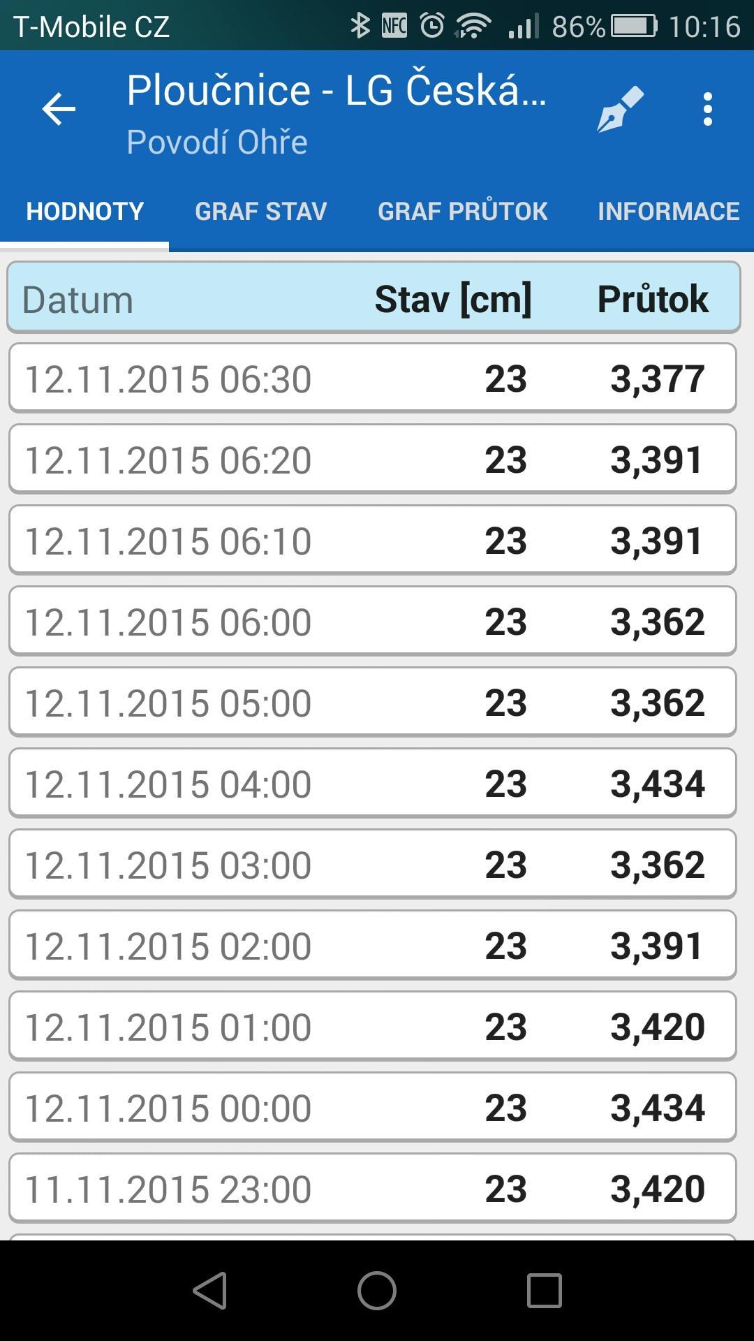
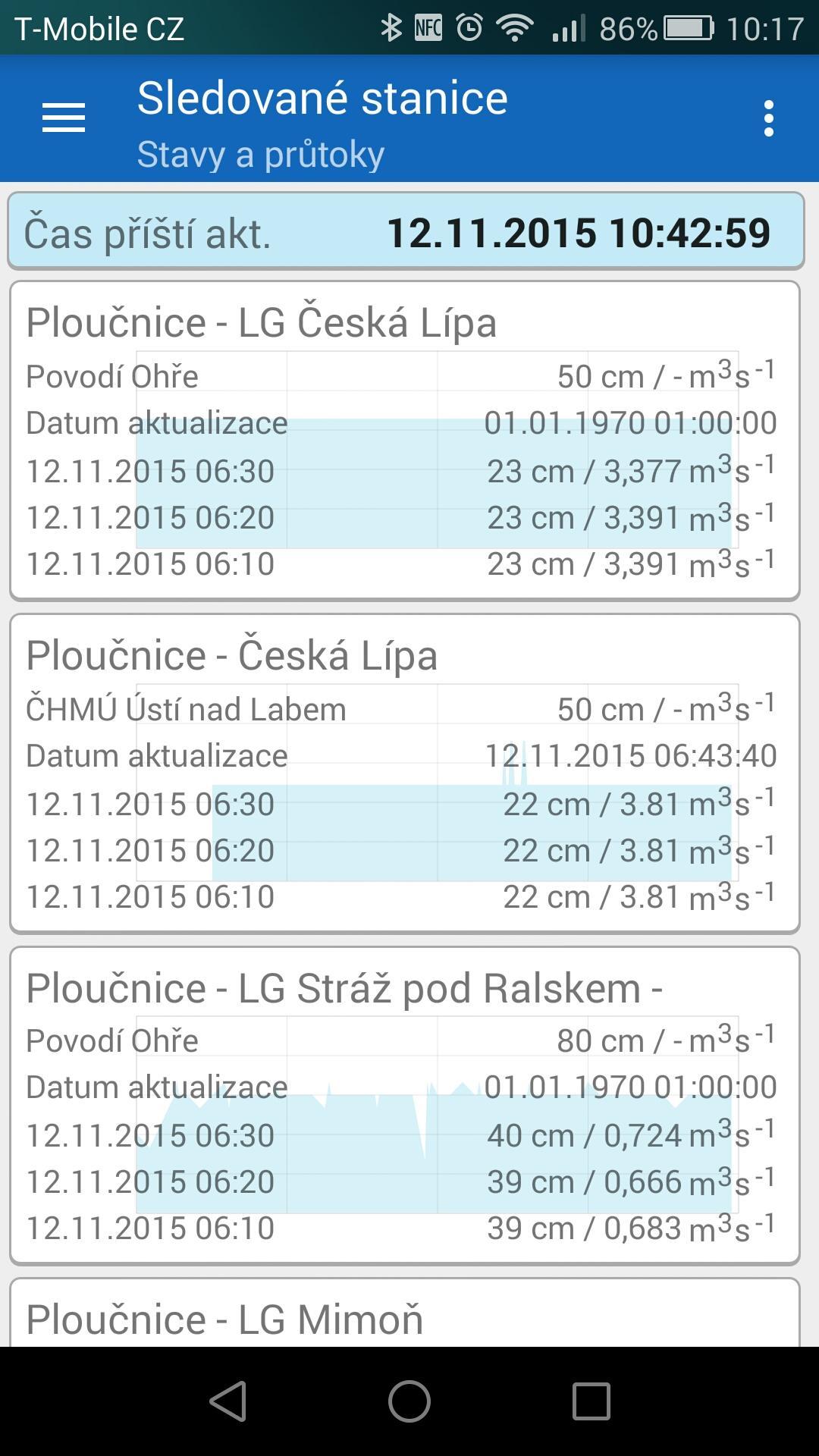
»Display of the list of watercourses of individual sources
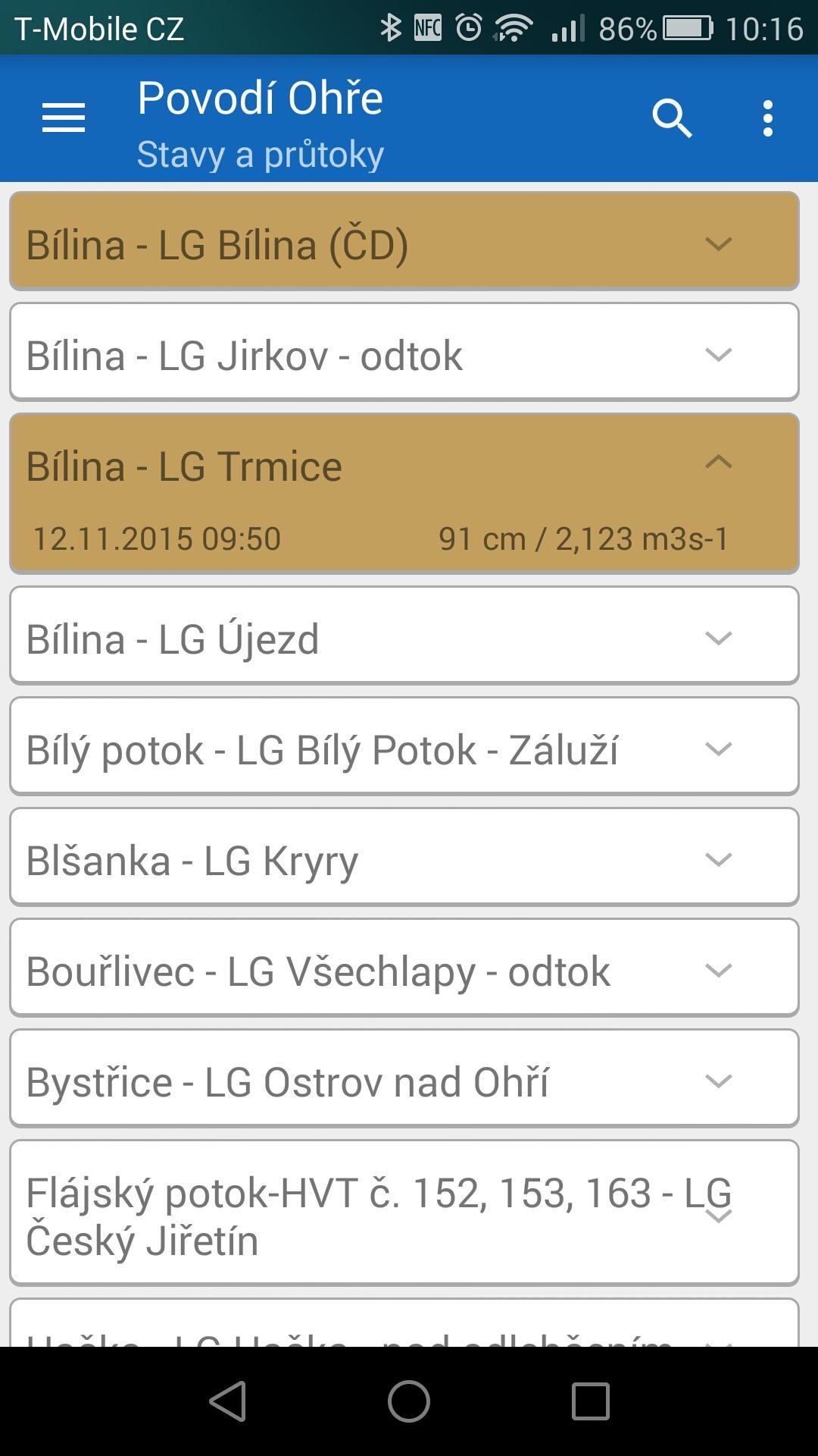
»Current information on the level and flow on individual streams (graphically highlighted according to the degree of flood activity)
»Basic information about the water flow (levels of flood activity levels)
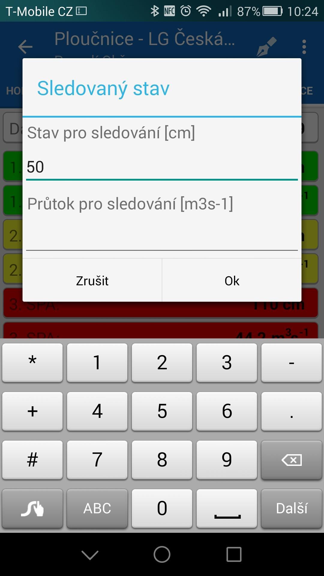
»Display of a warning if the monitored state (level) or flow on selected watercourses is exceeded
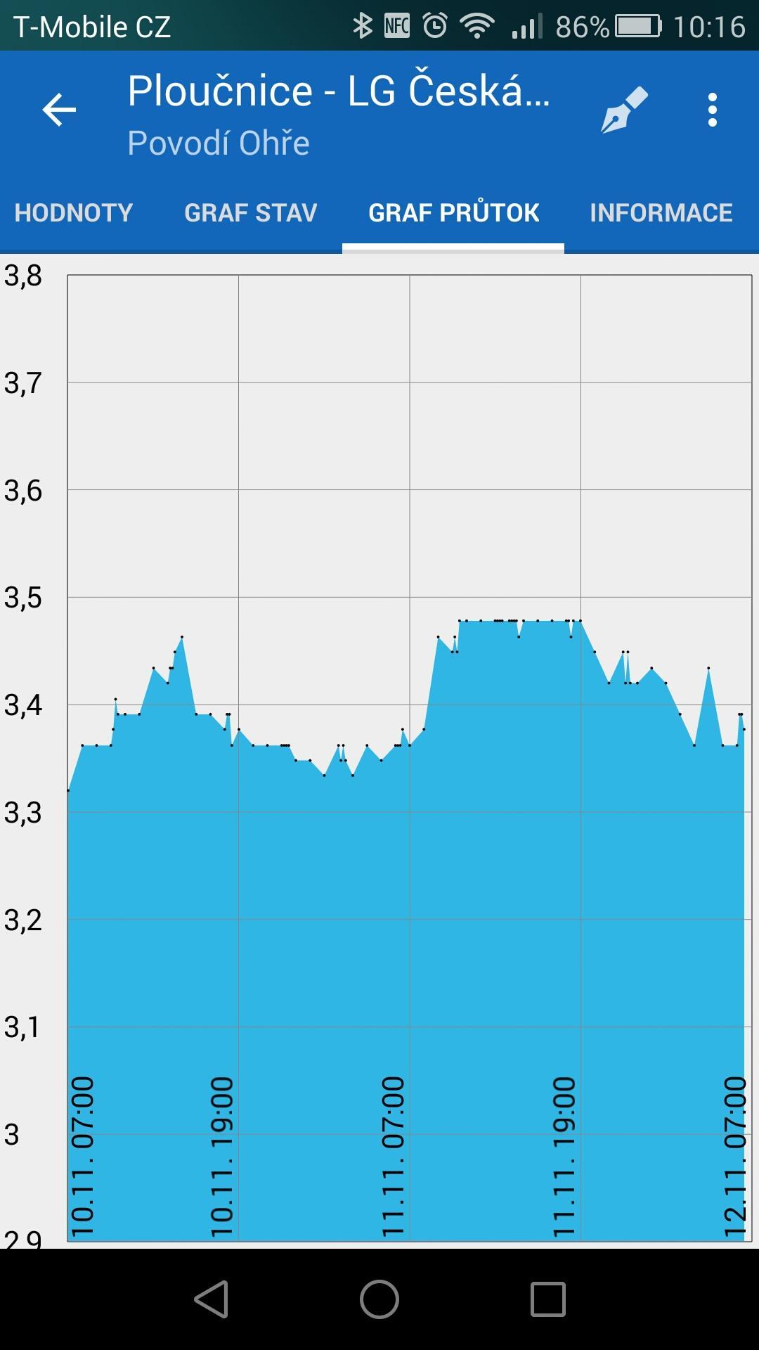
»Graph of state development display (levels)
»Graph of flow development display
»Widget of selected watched stations
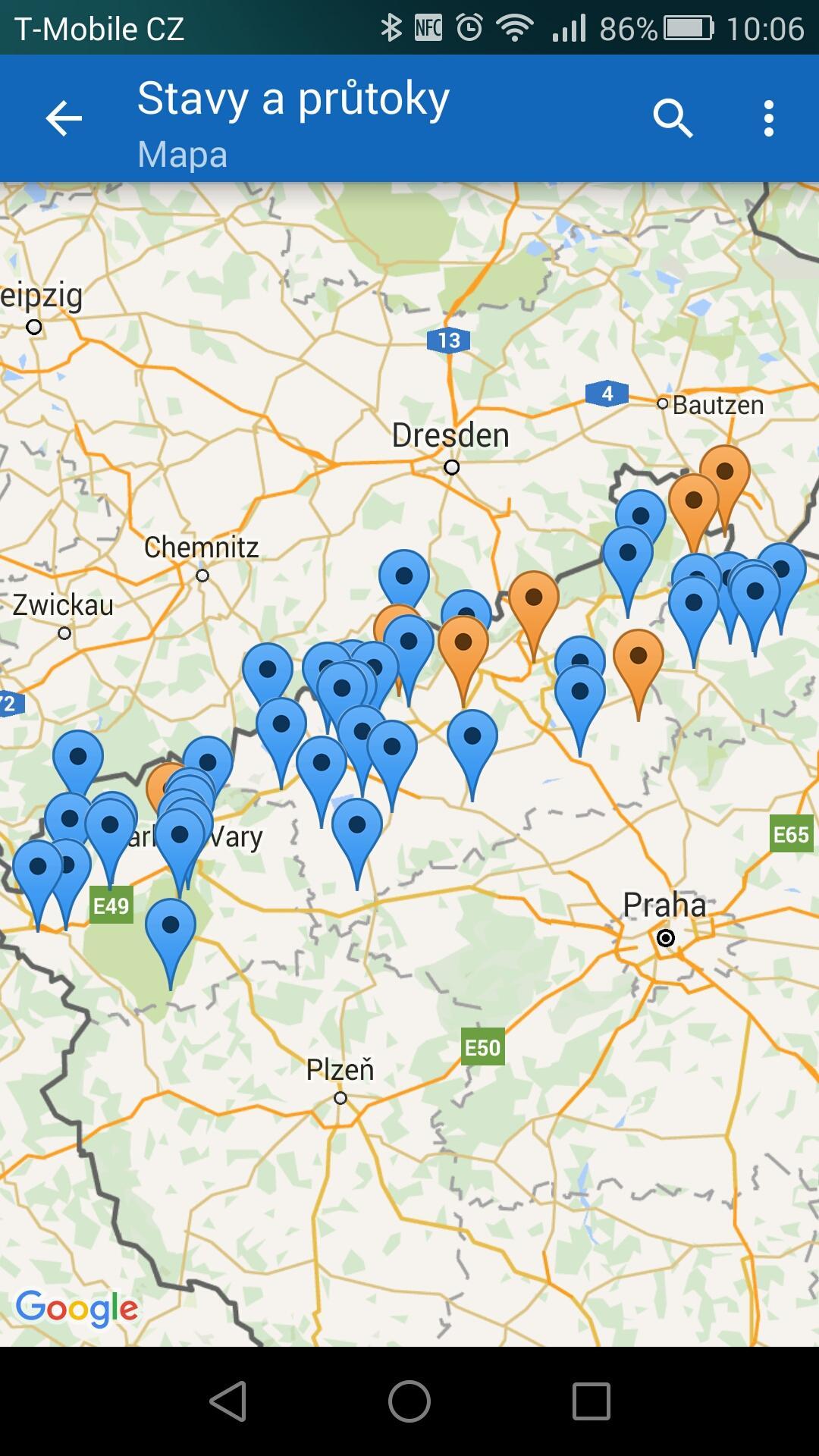
»View all stations, watched stations or a specific station on the map
»Edit the position of the station on the map
»Display and edit navigability information (for paddlers)
Testing new versions:
If any of you want to participate in the testing of new versions (beta), you need to click to log in as a tester at: https://play.google.com/apps/testing/cz.astran.stavyaprutoky
Now you will be offered updates to the beta version of the application in Google play.
Justification of the required permissions (the application does not use the permissions to damage user data, it also uses all the permissions it requires and needs it to function properly):
»Read SD card content / edit or delete SD card content
This permission requires the use of Google maps, which the application uses to display stations - probably caching map files.
»Read Google service configuration
This permission requires the use of Google maps, which the application uses to display stations.
»Search for accounts on your device
The application allows you to edit the positions of measuring stations on the map. However, there are those among us who might want to intentionally damage the data. Therefore, if unauthorized ("incorrect") coordinate changes occur, it is possible to disable this feature for a particular account.
Furthermore, the permission is used to remove the advertisement in case of a contribution to the application.
»Full network access
Without this permission, it would not be possible for the application to download any data - so it would not actually work.
»Start at startup
Only needed if you have set up automatic updates of watched stations. At system startup, the application saves the update time to the system timer and shuts down.
Sending data from the application:
The application securely sends some sensitive data (device id and device account name) to the application server https: \\ stavyaprutoky.cz after the user's permission.
The data provided in this way are used only for the possibility of removing the advertisement from the application or limiting the possibility of editing stations in the application to unruly users.
The sent data is used only for the needs of the application and is not provided to third parties.
What's New in the Latest Version 2.15.21
Last updated on Apr 16, 2024
Verze 2.15.21
Drobné úpravy kódu.
Verze 2.15.20
Drobné úpravy kódu.
Verze 2.15.19
Oprava načítání dat PS - Ústecký kraj.
Verze 2.15.18
Drobné úpravy kódu.
Verze 2.15.17
Úprava načtení seznamu stanic měst a obcí (LVS).
Verze 2.15.16
Oprava načítání dat ČHMÚ.
Verze 2.15.14
Oprava zobrazování notifikací pro Android 13.
Verze 2.15.13
Oprava načítání dat ČHMÚ.
Verze 2.15.12
Načítání dat ČHMÚ z nového serveru.
Verze 2.15.11
Rychlá oprava načítání dat ze serverů ČHMÚ.
Stavy a průtoky (Dams and Flows) is a Czech-language simulation game developed by SCS Software, known for its popular truck simulation series Euro Truck Simulator and American Truck Simulator. Released in 2014, Stavy a průtoky puts players in the role of a dam operator, responsible for managing water resources in a vast network of rivers, dams, and canals.
Gameplay
The primary objective of Stavy a průtoky is to maintain a stable and efficient water supply system while mitigating potential flooding risks. Players control a comprehensive array of dam systems, adjusting their gates and turbines to regulate water levels, flow rates, and power generation.
The game features a detailed simulation of water physics, with realistic modeling of water flow, pressure, and erosion. Players must carefully consider the impact of their decisions on the surrounding environment, including downstream communities, wildlife habitats, and floodplains.
Resource Management
Stavy a průtoky also incorporates resource management elements. Players must balance the competing demands of water supply, power generation, and flood control. Managing water levels requires constant monitoring of precipitation, evaporation, and demand patterns.
Dam Construction and Maintenance
In addition to operating existing dams, players can design and construct new dams to expand their water management capabilities. Dam construction involves selecting suitable locations, determining dam type and capacity, and managing construction costs.
Ongoing maintenance is crucial to ensure dam safety and efficiency. Players must regularly inspect and repair dam structures, address potential leaks or erosion, and upgrade aging infrastructure.
Realistic Environment
Stavy a průtoky features a meticulously crafted environment that mimics real-world river systems. Players navigate a complex network of interconnected rivers, canals, and reservoirs, each with its own unique characteristics and challenges.
The game's graphics engine provides stunning visuals, capturing the beauty and grandeur of nature. Realistic weather conditions, including rainfall, snowfall, and droughts, add an extra layer of challenge and realism.
Educational Value
Beyond its entertainment value, Stavy a průtoky serves as an educational tool. The game provides players with a deeper understanding of the principles of water management, dam engineering, and environmental sustainability.
By simulating real-world scenarios, Stavy a průtoky offers a valuable platform for exploring the complex interactions between water resources, infrastructure, and the environment.
Water levels and flows indicate status and water flow in watercourses Czech Republic and Slovakia
Are you interested in information about the state (level) and flow of watercourses?
Are you still tired of looking for information on the status and flow on the pages of individual river basins?
Does it need to be notified when the level of the selected water flow rises above your set limit?
Are you a paddler and are you interested in the passability of a popular stream?
The application States and flows of watercourses offers information on the status and flows of water in watercourses throughout the Czech and Slovak Republics. For paddlers, it also offers information on the navigability of streams.
Uses information:
1) from the pages of individual river basins:
»Ohře River Basin
»Vltava basin
»The Elbe basin
»The Morava River Basin
»The Odra River Basin
2) from the website of the Czech Hydrometeorological Institute - CHMI. In this case, the data are sorted according to CHMI branches:
»CHMI Brno
»CHMI České Budějovice
»CHMI Hradec Králové
»CHMI Ostrava
»CHMI Pilsen
»CHMI Prague
»CHMI Ústí nad Labem
3) from the pages of the flood system of small watercourses:
»DVT SESO (North Bohemian Association of Municipalities)
»DVT Pilsen
»DVT Hranice
»DVT Bystřice
»DVT Easter Eggs
»DVT KRKV (Karlovy Vary Region)
»DVT Tábor
»DVT Lanškroun
»DVT Říčany
4) from the Hladiny.cz website:
»Stations of towns and municipalities (LVS)
5) from the VOX warning systems website:
»VOX - levels
6) from the pages of the SK river basin:
»OZ Bratislava
»OZ Piešťany
»OZ Banská Bystrica
»OZ Košice
7) from the website of the Slovak Hydrometeorological Institute - SHMÚ:
»SHMÚ Bratislava region
»SHMÚ Žilina region
»SHMÚ Banskobystrický region
»SHMÚ Košice region
Application functions:
»Display of the list of watercourses of individual sources
»Current information on the level and flow on individual streams (graphically highlighted according to the degree of flood activity)
»Basic information about the water flow (levels of flood activity levels)
»Display of a warning if the monitored state (level) or flow on selected watercourses is exceeded
»Graph of state development display (levels)
»Graph of flow development display
»Widget of selected watched stations
»View all stations, watched stations or a specific station on the map
»Edit the position of the station on the map
»Display and edit navigability information (for paddlers)
Testing new versions:
If any of you want to participate in the testing of new versions (beta), you need to click to log in as a tester at: https://play.google.com/apps/testing/cz.astran.stavyaprutoky
Now you will be offered updates to the beta version of the application in Google play.
Justification of the required permissions (the application does not use the permissions to damage user data, it also uses all the permissions it requires and needs it to function properly):
»Read SD card content / edit or delete SD card content
This permission requires the use of Google maps, which the application uses to display stations - probably caching map files.
»Read Google service configuration
This permission requires the use of Google maps, which the application uses to display stations.
»Search for accounts on your device
The application allows you to edit the positions of measuring stations on the map. However, there are those among us who might want to intentionally damage the data. Therefore, if unauthorized ("incorrect") coordinate changes occur, it is possible to disable this feature for a particular account.
Furthermore, the permission is used to remove the advertisement in case of a contribution to the application.
»Full network access
Without this permission, it would not be possible for the application to download any data - so it would not actually work.
»Start at startup
Only needed if you have set up automatic updates of watched stations. At system startup, the application saves the update time to the system timer and shuts down.
Sending data from the application:
The application securely sends some sensitive data (device id and device account name) to the application server https: \\ stavyaprutoky.cz after the user's permission.
The data provided in this way are used only for the possibility of removing the advertisement from the application or limiting the possibility of editing stations in the application to unruly users.
The sent data is used only for the needs of the application and is not provided to third parties.
What's New in the Latest Version 2.15.21
Last updated on Apr 16, 2024
Verze 2.15.21
Drobné úpravy kódu.
Verze 2.15.20
Drobné úpravy kódu.
Verze 2.15.19
Oprava načítání dat PS - Ústecký kraj.
Verze 2.15.18
Drobné úpravy kódu.
Verze 2.15.17
Úprava načtení seznamu stanic měst a obcí (LVS).
Verze 2.15.16
Oprava načítání dat ČHMÚ.
Verze 2.15.14
Oprava zobrazování notifikací pro Android 13.
Verze 2.15.13
Oprava načítání dat ČHMÚ.
Verze 2.15.12
Načítání dat ČHMÚ z nového serveru.
Verze 2.15.11
Rychlá oprava načítání dat ze serverů ČHMÚ.
Stavy a průtoky (Dams and Flows) is a Czech-language simulation game developed by SCS Software, known for its popular truck simulation series Euro Truck Simulator and American Truck Simulator. Released in 2014, Stavy a průtoky puts players in the role of a dam operator, responsible for managing water resources in a vast network of rivers, dams, and canals.
Gameplay
The primary objective of Stavy a průtoky is to maintain a stable and efficient water supply system while mitigating potential flooding risks. Players control a comprehensive array of dam systems, adjusting their gates and turbines to regulate water levels, flow rates, and power generation.
The game features a detailed simulation of water physics, with realistic modeling of water flow, pressure, and erosion. Players must carefully consider the impact of their decisions on the surrounding environment, including downstream communities, wildlife habitats, and floodplains.
Resource Management
Stavy a průtoky also incorporates resource management elements. Players must balance the competing demands of water supply, power generation, and flood control. Managing water levels requires constant monitoring of precipitation, evaporation, and demand patterns.
Dam Construction and Maintenance
In addition to operating existing dams, players can design and construct new dams to expand their water management capabilities. Dam construction involves selecting suitable locations, determining dam type and capacity, and managing construction costs.
Ongoing maintenance is crucial to ensure dam safety and efficiency. Players must regularly inspect and repair dam structures, address potential leaks or erosion, and upgrade aging infrastructure.
Realistic Environment
Stavy a průtoky features a meticulously crafted environment that mimics real-world river systems. Players navigate a complex network of interconnected rivers, canals, and reservoirs, each with its own unique characteristics and challenges.
The game's graphics engine provides stunning visuals, capturing the beauty and grandeur of nature. Realistic weather conditions, including rainfall, snowfall, and droughts, add an extra layer of challenge and realism.
Educational Value
Beyond its entertainment value, Stavy a průtoky serves as an educational tool. The game provides players with a deeper understanding of the principles of water management, dam engineering, and environmental sustainability.
By simulating real-world scenarios, Stavy a průtoky offers a valuable platform for exploring the complex interactions between water resources, infrastructure, and the environment.


